Filter: Categories of Wisconsin Historical Images
Filter: Subject of Rivers
Filter: Creator Name of Unknown
Filter: County of Sauk
Filter: Categories of Wisconsin Historical Images
Filter: Subject of Rivers
Filter: Creator Name of Unknown
Filter: County of Sauk
| Date: | 1914 |
|---|---|
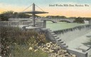
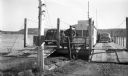
| Description: | Slightly elevated view of the dam, with a bridge in the background. Caption reads: "Island Wollen Mills Dam, Baraboo, Wis." |
| Date: | 1940 |
|---|---|
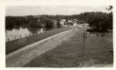
| Description: | View of town from the south, with the Baraboo River on the other side of the road. |
| Date: | 1920 |
|---|---|
| Description: | View of the Wisconsin River Bridge in the vicinity of Spring Green. |

| Date: | 1859 |
|---|---|
| Description: | Map featuring various views of buildings and scenes from Sauk County. |
| Date: | 1940 |
|---|---|
| Description: | Colsac Ferry across the Wisconsin River at Merrimac. There is a bridge across the river in the background on the left. |
| Date: | 1924 |
|---|---|
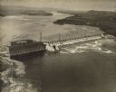
| Description: | Aerial view of the Prairie du Sac hydroelectric plant and the surrounding landscape of the Wisconsin River. |
| Date: | 1920 |
|---|---|
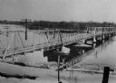
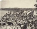
| Description: | Crowd gathered for the dedication of a new bridge at Sauk City by Governor Emmanuel Philipp. Many onlookers carry parasols. |
| Date: | 1900 |
|---|---|
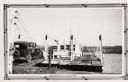
| Description: | Car boarding the ferry on left side. The far shoreline can be seen in the background. |
| Date: | |
|---|---|
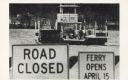
| Description: | The Merrimac ferry "Colsac II" is seen on the Wisconsin River behind two signs. The signs read, "Road Closed" and "Ferry Opens April 15". |

| Date: | 1912 |
|---|---|
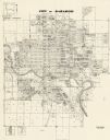
| Description: | This outline map of Sauk County, Wisconsin, shows the towns, cities and villages, railroads, and streams in the county. |

| Date: | 1990 |
|---|---|
| Description: | This late 20th century tourist map of Sauk County, Wisconsin, shows the highways and roads, cities and towns, parks, airports, canoe landings, hospitals, s... |

| Date: | 1909 |
|---|---|
| Description: | Elevated view of the Baraboo River. The main part of town is on the far left shoreline. On the right industrial buildings are near a bridge spanning the ri... |
| Date: | 1972 |
|---|---|
| Description: | This map shows plat of the city, city limits, local streets, and part of the Baraboo River. The map includes 3 inset maps. |
| Date: | |
|---|---|
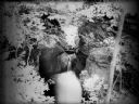
| Description: | View looking down at Skillet Creek Falls, which are surrounded by rocks, trees and foliage. Skillet Creek, located on private land, flows to Pewit's Nest, ... |

| Date: | 1903 |
|---|---|
| Description: | This blue line print shows quartzite areas, mines, railroads, and roads. The map covers townships 11-13 north, ranges 4-8 east, in parts of Sauk and Columb... |

| Date: | 11 28 1908 |
|---|---|
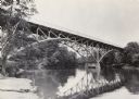
| Description: | Text on front reads: "High Bridge, Baraboo, Wis." A truss bridge over the Baraboo River with a spillway underneath. The shorelines are wooded and buildings... |
| Date: | 1950 |
|---|---|
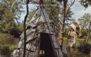
| Description: | Text on front reads: "Greetings from Spring Green." On the reverse it reads: "Be It Ever So Humble..." A Native American man dressed in indigenous clothing... |
| Date: | 1922 |
|---|---|
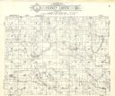
| Description: | A plat map of the Township of Honey Creek, created by Geo. A. Ogle & Co. |
If you didn't find the material you searched for, our Library Reference Staff can help.
Call our reference desk at 608-264-6535 or email us at: