 Filter: Categories of Wisconsin Historical Images
Filter: Subject of Rivers
Filter: Creator Name of Unknown
Filter: County of Ashland
Filter: Categories of Wisconsin Historical Images
Filter: Subject of Rivers
Filter: Creator Name of Unknown
Filter: County of Ashland
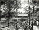
| Date: | 1940 |
|---|---|
| Description: | People on a rustic bridge over river at Copper Falls State Park. A long log building is in the background on the other side of the river. |
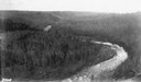
| Date: | |
|---|---|
| Description: | Aerial view of the Big Goose Neck in the Bad River at Copper Falls State Park. |
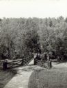
| Date: | |
|---|---|
| Description: | Two people on a rustic bridge over Bad River at Copper Falls State Park. |
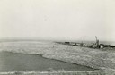
| Date: | 1945 |
|---|---|
| Description: | Elevated view of logs stored in a logging boom on Chequamegon Bay. |
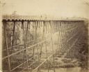
| Date: | 1885 |
|---|---|
| Description: | Elevated view of the Wiscsonsin Central's bridge over the White River, about six miles south of Ashland. The bridge was 1600 ft. long and 110 ft. above the... |
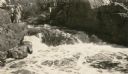
| Date: | 1929 |
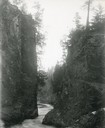
|---|---|
| Description: | The gorge of the Bad River below Brownstone Falls. |
| Date: | |
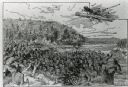
|---|---|
| Description: | An illustration titled "The Battle of the Brule" based on an 1840's battle between the Ojibwe and Dakota Sioux over territory in the Ashland, Wisconsin are... |

| Date: | 1880 |
|---|---|
| Description: | Man in canoe close to shoreline with a bridge in the background. |
| Date: | |
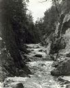
|---|---|
| Description: | View up the Bad River Gorge below Copper Falls at Copper Falls State Park. |
| Date: | 1940 |
|---|---|
| Description: | Two rustic stairways leading down to the Bad River at Copper Falls State Park. At the bottom of the stairs is a sign telling the geological story of Copper... |

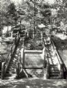
| Date: | 1949 |
|---|---|
| Description: | This 1949 map shows the topography and significant landmarks in Copper Falls State Park, Ashland County, Wisconsin. |
| Date: | 1931 |
|---|---|
| Description: | A group of people stand on a ledge overlooking Copper Falls. |

| Date: | 1910 |
|---|---|
| Description: | This map shows the locations of school houses, farms, roads, railroads, and Bad River Indian Reservation. Relief is shown by hachures. Yellow and red manus... |
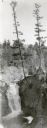
| Date: | 1930 |
|---|---|
| Description: | An elevated view of Brownstone Falls. Two tall pines are growing at the top edge of a rock to the right of the falls. |
If you didn't find the material you searched for, our Library Reference Staff can help.
Call our reference desk at 608-264-6535 or email us at:
