 Filter: Categories of Wisconsin Historical Images
Filter: Subject of Restaurants
Filter: Subject of rivers
Filter: Categories of Wisconsin Historical Images
Filter: Subject of Restaurants
Filter: Subject of rivers
| Date: | |
|---|---|
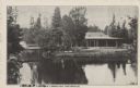
| Description: | Black and white postcard view of the President's Dining Lodge on the Brule River surrounded by trees. A bridge is on the left. Caption reads: "President's ... |

| Date: | 1920 |
|---|---|
| Description: | A two-sided map of the state of Wisconsin. The front includes towns and major cities as well as state and county trunk highways. The back includes a smalle... |

| Date: | 1940 |
|---|---|
| Description: | This pictorial map shows points of interest, recreation activities, and highways in the vicinity of the restaurant and covers the Wisconsin River Valley be... |

| Date: | 1935 |
|---|---|
| Description: | This blue lined map ("compliments of Black Eagle Oil Company") shows the major roads and cities of Wisconsin. The map includes an index, hotel and cafe adv... |

| Date: | 1935 |
|---|---|
| Description: | This road map shows automobile routes across the state of Wisconsin. Advertisements for various hotels are featured along the bottom edge of the map, while... |
| Date: | 06 1938 |
|---|---|
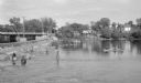
| Description: | View across water on a sunny day, where many anglers are fishing below the Indian Ford dam and bridge on the Rock river. Some of the men are fishing from t... |
If you didn't find the material you searched for, our Library Reference Staff can help.
Call our reference desk at 608-264-6535 or email us at: