 Filter: Categories of Wisconsin Historical Images
Filter: Subject of Resorts
Filter: Year of 1900-1999
Filter: Year of 1970-1979
Filter: Categories of Wisconsin Historical Images
Filter: Subject of Resorts
Filter: Year of 1900-1999
Filter: Year of 1970-1979
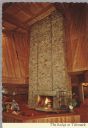
| Date: | 09 02 1975 |
|---|---|
| Description: | Color postcard of the interior of the Lodge at Telemark showing one of the largest stone fireplaces in the world. It is constructed out of 155 tons of nati... |

| Date: | 1977 |
|---|---|
| Description: | This pictorial map was produced by the Chateau, a resort in La Pointe, and shows Madeline Island landmarks and tourist attractions. On the verso is the spr... |

| Date: | 1974 |
|---|---|
| Description: | This 1968 map identifies resorts in the Lac du Flambeau Indian Reservation region of Wisconsin, covering parts of Iron, Vilas, Oneida, and Price counties. ... |

| Date: | 1975 |
|---|---|
| Description: | This map shows nature trails, public attractions, public hunting and fishing grounds, dams, waysides, lakes, highways, and roads. The upper right corner in... |

| Date: | 1976 |
|---|---|
| Description: | This colored map displays Wisconsin and portions of bordering states, including a detailed map of the Wisconsin Dells area. Surrounding the map are multipl... |

| Date: | 1977 |
|---|---|
| Description: | This colored map displays Wisconsin and portions of bordering states, including a detailed map of the Wisconsin Dells area. Surrounding the map are multipl... |

| Date: | 1975 |
|---|---|
| Description: | Colored bird's-eye map of the Lake Region of Waukesha County. Looking North from Government Hill. All these Lakes and Resorts are withing Four hours ride o... |
If you didn't find the material you searched for, our Library Reference Staff can help.
Call our reference desk at 608-264-6535 or email us at: