 Filter: Categories of Wisconsin Historical Images
Filter: Subject of Resorts
Filter: Subject of streams
Filter: Categories of Wisconsin Historical Images
Filter: Subject of Resorts
Filter: Subject of streams
| Date: | |
|---|---|
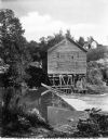
| Description: | Elevated view of the banks along a fishing stream, with a few buildings on the other side of the water. Caption reads: "Great Fishing Resort Near Kirksvill... |

| Date: | 1914 |
|---|---|
| Description: | This 1914 map of Price County, Wisconsin, shows land for sale by the Good Land Company and Dewitt van Ostrand of Phillips. Also shown are the township and ... |
| Date: | 12 1900 |
|---|---|
| Description: | This manuscript map from 1900 shows resorts, lakes, rivers and streams, roads, railroads, and telephone lines in northwest Vilas County, in the towns of Bo... |

| Date: | 1974 |
|---|---|
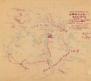
| Description: | This 1968 map identifies resorts in the Lac du Flambeau Indian Reservation region of Wisconsin, covering parts of Iron, Vilas, Oneida, and Price counties. ... |

| Date: | 1941 |
|---|---|
| Description: | This 1941 map covers Washburn County, Wisconsin, as well as western Sawyer, eastern Burnett, and northeastern Polk counties. It shows the locations of tour... |

| Date: | 1940 |
|---|---|
| Description: | Map shows hydrography and location of game fish in part of Vilas County, Wisconsin and Gogebic County, Michigan. |

| Date: | 1909 |
|---|---|
| Description: | This 1909 map of northern Wisconsin and a portion of Michigan's Upper Peninsula shows the Lac du Flambeau Indian Reservation, cities and villages, railroad... |

| Date: | 1953 |
|---|---|
| Description: | This mid 20th century map of Vilas County and northeastern Oneida County, Wisconsin, shows the township and range grid, sections, cities and villages, rail... |

| Date: | 07 13 1918 |
|---|---|
| Description: | View of Seven Pines Lodge, a north woods resort. A log structure is on a hill, and a stream is at the bottom of the steps. Caption reads: "'Seven Pines' Le... |
If you didn't find the material you searched for, our Library Reference Staff can help.
Call our reference desk at 608-264-6535 or email us at: