 Filter: Categories of Wisconsin Historical Images
Filter: Subject of Resorts
Filter: Subject of camps
Filter: Categories of Wisconsin Historical Images
Filter: Subject of Resorts
Filter: Subject of camps
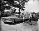
| Date: | 06 1959 |
|---|---|
| Description: | Two men with cameras around their necks stand near a couple in a Plymouth pulling an airstream camper through a gate. The sign on the gate in the backgroun... |
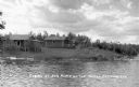
| Date: | 1933 |
|---|---|
| Description: | Modest cabins located along shoreline of Turtle Flowage on a cloudy day. |
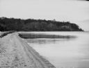
| Date: | |
|---|---|
| Description: | A view of the beach at Smokey Point Resort, on Big Leech Lake. |

| Date: | 07 10 1950 |
|---|---|
| Description: | Photographic postcard view of two cabins surrounded by a lawn and trees at the Wonderspot Resort. Caption reads: "Wonderspot Cabins, Bruce, Wis." |
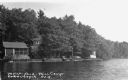
| Date: | 1937 |
|---|---|
| Description: | View from water of cabins and boats near shoreline of inland lake. |

| Date: | 1937 |
|---|---|
| Description: | Two people holding a stringer of trout caught on Siskiwit Lake. |

| Date: | 1926 |
|---|---|
| Description: | This 1926 map depicts resorts and camps, lakes and streams, railroads, and roads in portions of Vilas, Iron, Oneida, Price, and Lincoln counties in Wiscons... |

| Date: | 1953 |
|---|---|
| Description: | This mid 20th century map of Vilas County and northeastern Oneida County, Wisconsin, shows the township and range grid, sections, cities and villages, rail... |
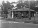
| Date: | 1931 |
|---|---|
| Description: | A view of the Log Cabin Filling Station at a tourist camp. A garage for washing and greasing on the left. Two tall gas pumps. Lamps made of interlaced logs... |
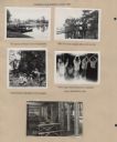
| Date: | |
|---|---|
| Description: | Page from Sue Ann Hackett Blue Album displaying several scenes from a canoe trip on the Lower Kaubashine Creek. Includes photographs of Joy Camps canoes on... |

| Date: | 1939 |
|---|---|
| Description: | This brochure was intended for tourists and shows resorts, lakes and railroads in northwestern Wisconsin and part of Michigan’s upper peninsula. Also inclu... |

| Date: | 1952 |
|---|---|
| Description: | This map shows roads, foot and canoe trails, railroads, resorts, lookout towers, camps, national and state forests, Indian reservation, and types of fish i... |

| Date: | 1969 |
|---|---|
| Description: | This map shows ski areas, resorts, camps, special areas, airports, and roads. The map covers Vilas and Oneida counties and parts of Iron, Price, Lincoln, L... |

| Date: | 1951 |
|---|---|
| Description: | This map shows land use, dwellings, resorts, camps, marshes, springs, dams, lake bottom composition, and access. The map includes a fish species table, geo... |

| Date: | 1940 |
|---|---|
| Description: | This map shows lakes, roads, car trails, foot trails, railroads, resorts and camps, and fire towers. The map includes an inset location map and pictorial d... |

| Date: | 1941 |
|---|---|
| Description: | This map highlights the fishing district and shows labeled rivers, lakes, cities, county boundaries and points of interest. The map includes a list of trai... |

| Date: | 1922 |
|---|---|
| Description: | This map shows in red the NorthWestern Railway Line routes running from Chicago, Illinois to northern Wisconsin. The map includes cities and towns, lakes, ... |
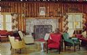
| Date: | 1950 |
|---|---|
| Description: | Text on reverse reads: "Interior of the Lodge – Moon Beach Camp. Rt. 1, St. Germain, Wisconsin." Comfortable chairs and a sofa are grouped in front o... |

| Date: | 06 24 1964 |
|---|---|
| Description: | Text on front reads: "The Beach, Audubon Camp. Sarona, Wis." A view of a wooden dock and lake from the shore. Three people are in a canoe, with a floating ... |

| Date: | 06 07 1966 |
|---|---|
| Description: | Text on front reads: "Audubon Camp, Sarona, Wis." A view of the headquarters buildings, house on the left, parked cars on the right, barn in the background... |
If you didn't find the material you searched for, our Library Reference Staff can help.
Call our reference desk at 608-264-6535 or email us at: