 Filter: Categories of Wisconsin Historical Images
Filter: Subject of Reservoirs
Filter: Subject of human settlements
Filter: Year of 1900-1999
Filter: Categories of Wisconsin Historical Images
Filter: Subject of Reservoirs
Filter: Subject of human settlements
Filter: Year of 1900-1999

| Date: | 1930 |
|---|---|
| Description: | Aerial view of city, with Eau Claire River is in the foreground with Milwaukee railroad bridge at left. Gillette Rubber Co. plant is in center with Omaha r... |

| Date: | 02 06 1948 |
|---|---|
| Description: | Aerial view of west side, looking south along Glenway Street. Visible are the reservoir, Lake Wingra, Forest Hill and Resurrection Cemetery, Hoyt Park. Maj... |

| Date: | 02 06 1948 |
|---|---|
| Description: | Aerial photograph looking northwest across the reservoir on Glenway Street. Featured are Hoyt and Quarry Parks, Resurrection Cemetery. Major streets are Fr... |

| Date: | 02 06 1948 |
|---|---|
| Description: | Looking north along Glenway Street. Visible are the reservoir, Hoyt and Quarry Parks, Resurrection and Forest Hill Cemeteries, Rentschler Greenhouses, Fore... |

| Date: | 02 06 1948 |
|---|---|
| Description: | Looking southeast across Speedway Road. Visible are the reservoir on Glenway Street, Hoyt Park, Resurrection and Forest Hill cemeteries, Glenway Golf cours... |

| Date: | 02 06 1948 |
|---|---|
| Description: | Looking east along Regent Street with snow on the ground. Visible are Lake Wingra, Monona Bay, railroad causeway across Monona, Lake Mendota, Hoyt Park, We... |
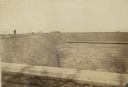
| Date: | 1900 |
|---|---|
| Description: | Reservoir, looking South, with pedestrians walking along the edge of the empty reservoir. A team of horses with a cart or wagon can also be seen in the bac... |
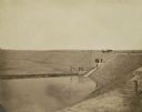
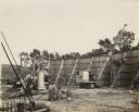
| Date: | 1900 |
|---|---|
| Description: | Looking down into the reservoir partially filled with water. A group of men stand at various levels; some with the carriage and horses at top, four on a le... |
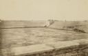
| Date: | 1900 |
|---|---|
| Description: | Several men are standing on top of a square ledge over the reservoir. Other men are working in the reservoir. On the right is a wooden walkway. |

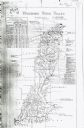
| Date: | 1930 |
|---|---|
| Description: | This map shows Indian trails through Wisconsin counties. The trail are in red ink. Lake Michigan, Green Bay, Lake Superior, and the Wisconsin River are lab... |
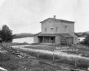
| Date: | 1924 |
|---|---|
| Description: | The Humbird Roller Mill surrounded by rural landscape. A man leads on a porch beam as he poses for the picture. |
| Date: | 1925 |
|---|---|
| Description: | A building site with "O'Dea and Shafer, Engineers and Contractors" construction crew, crane and other equipment. On the photograph album binding on the lef... |
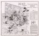
| Date: | 1987 |
|---|---|
| Description: | This map shows reservoirs, drainage areas, and parts of of Lincoln, Langlade, Forest, Oneida, and Vilas counties. Includes 1 inset map of corrections for R... |

| Date: | 1941 |
|---|---|
| Description: | This is map three of a set of three, and shows trails, roads and fire lanes, utilities, resorts, submerged lakes, vegetation, flowage right lands, and timb... |

| Date: | 1912 |
|---|---|
| Description: | This blueprint manuscript map shows landownership, mills, railroad, churches, public buildings, the old cemetery, and the Chippewa River and Reservoir. The... |

| Date: | 1900 |
|---|---|
| Description: | Elevated view across river of McCormick Works. |
| Date: | 1911 |
|---|---|
| Description: | This map includes references to reservoirs, industrial sites, and drainage basins. |

| Date: | 01 01 1959 |
|---|---|
| Description: | This map shows many of the rivers, dams, bays, harbors, lakes, and canals. It includes an index of authorized federal project, both for navigation and floo... |

| Date: | 1968 |
|---|---|
| Description: | Two ducks are silhouetted on the Chippewa Flowage at sunrise or sunset. |
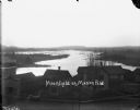
| Date: | 1900 |
|---|---|
| Description: | Elevated view over the tops of buildings to the water beyond. A wooden sidewalk and fence runs along the street in the foreground. Caption on negative read... |
If you didn't find the material you searched for, our Library Reference Staff can help.
Call our reference desk at 608-264-6535 or email us at: