 Filter: Categories of Wisconsin Historical Images
Filter: Subject of Research
Filter: Subject of rivers
Filter: Categories of Wisconsin Historical Images
Filter: Subject of Research
Filter: Subject of rivers

| Date: | 1865 |
|---|---|
| Description: | Map showing the location of meteorological stations and effects that Lake Michigan has had on Wisconsin temperatures in January and July. The map shows cou... |

| Date: | 08 1960 |
|---|---|
| Description: | This map shows a detailed account of southwestern Wisconsin. Individual settlers, the type of trees that grow in given areas, the quality of the soil (labe... |

| Date: | |
|---|---|
| Description: | Two young women wearing waders are standing in a creek or small river. One of the women is holding a net just above the water, while the other women is exa... |
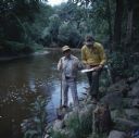
| Date: | 10 1978 |
|---|---|
| Description: | Two men are standing on the rocky shoreline of the Sheboygan River. One man is holding a shovel in his right hand and a glass jar in his left hand. The oth... |
If you didn't find the material you searched for, our Library Reference Staff can help.
Call our reference desk at 608-264-6535 or email us at: