 Filter: Categories of Wisconsin Historical Images
Filter: Subject of Research
Filter: Subject of forests and forestry
Filter: Categories of Wisconsin Historical Images
Filter: Subject of Research
Filter: Subject of forests and forestry

| Date: | 08 1960 |
|---|---|
| Description: | This map shows a detailed account of southwestern Wisconsin. Individual settlers, the type of trees that grow in given areas, the quality of the soil (labe... |

| Date: | 01 13 1937 |
|---|---|
| Description: | Sketch map of Township 7 North, Range 9 East, created for the Land Economic Inventory (Bordner Survey). The map shows Picnic Point and the Lake Mendota sho... |

| Date: | |
|---|---|
| Description: | Two men wearing jumpsuits and hard hats are measuring a tree. One man is holding up a measuring tape across the width of the tree as the other man writes o... |
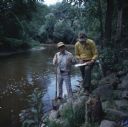
| Date: | 10 1978 |
|---|---|
| Description: | Two men are standing on the rocky shoreline of the Sheboygan River. One man is holding a shovel in his right hand and a glass jar in his left hand. The oth... |

| Date: | 06 24 1958 |
|---|---|
| Description: | Three attendees at the National Forest Products Research Society conference are Richard Haussman, U.S. Forest Service; John Lutz, Forest Products Laborator... |
If you didn't find the material you searched for, our Library Reference Staff can help.
Call our reference desk at 608-264-6535 or email us at: