 Filter: Categories of Wisconsin Historical Images
Filter: Subject of Recreation
Filter: Subject of fish hatcheries
Filter: Categories of Wisconsin Historical Images
Filter: Subject of Recreation
Filter: Subject of fish hatcheries

| Date: | 1935 |
|---|---|
| Description: | Two men, each in a wooden row boat, collect pike fish from a fyke net on a northern Wisconsin lake. One man is standing in his boat holding a fish net hold... |
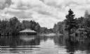
| Date: | 1932 |
|---|---|
| Description: | View across water of The Flowage showing the Mercer Fish Hatchery building on the left. Two people are in a boat on the far left, a bridge is in the center... |

| Date: | 1926 |
|---|---|
| Description: | A brochure with a map of Interstate Park on the Dalles of the Saint Croix River, showing locations of the north and south camp grounds, the fish hatcheries... |

| Date: | 1947 |
|---|---|
| Description: | This map shows various types of forests, nurseries, state fish hatcheries, major wood-using industries, camp & picnic grounds, fire towers, ranger stations... |
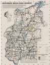
| Date: | 1950 |
|---|---|
| Description: | This map covers the fifteen counties lying in the northwestern part of the state of Wisconsin. Shows roads, railroads, state parks, cities, county boundari... |

| Date: | 1930 |
|---|---|
| Description: | This map shows roads and lakes and includes an inset illustration of Manitowish Waters Fish Hatchery. The back of the map includes a resorts directory, tex... |
If you didn't find the material you searched for, our Library Reference Staff can help.
Call our reference desk at 608-264-6535 or email us at: