Filter: Categories of Wisconsin Historical Images
Filter: Subject of Recreation
Filter: Subject of bays
Filter: Categories of Wisconsin Historical Images
Filter: Subject of Recreation
Filter: Subject of bays

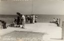
| Date: | 1909 |
|---|---|
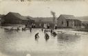
| Description: | View of a boating scene off of the shore of Marinette and Menominee. Two boys are walking on the pier on the left, and a crowd of people are gathered at th... |
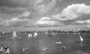
| Date: | |
|---|---|
| Description: | A bay with sailboats and other small craft, and a view of the shoreline and town beyond. |

| Date: | 1957 |
|---|---|
| Description: | Large Letter style postcard for Green Bay depicting various scenes in the letters that spell the name of the city. Caption reads: "Greetings from Green Bay... |

| Date: | 1916 |
|---|---|
| Description: | This Wisconsin Conservation Commission map from 1916 shows Peninsula State Park in the Town of Gibraltar, Door County, Wisconsin. Depicted are open and pla... |

| Date: | 1916 |
|---|---|
| Description: | This version of a 1916 Wisconsin Conservation Commission map shows Peninsula State Park in the Town of Gibraltar, Door County, Wisconsin. Depicted are open... |

| Date: | 1932 |
|---|---|
| Description: | This map of Superior shows many points of interests including camping, fair grounds, docks, tourist attractions, lakes, roads, and waterways. |
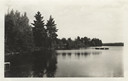
| Date: | |
|---|---|
| Description: | View from Camp Pioneer looking east along the north shore of bay (Lake Raymond, now known as Seventeen Lake). There are piers on the shoreline, and a raft ... |
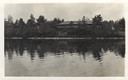
| Date: | |
|---|---|
| Description: | View over water of Main Lodge as seen from boat on bay. Original caption notes: "It fits well into the landscape and seems to have been there always. Forty... |

| Date: | 1966 |
|---|---|
| Description: | A colored map depiction of Door County, Wisconsin, with pictorial highlights, titled: "Door County — Wisconsin's Air Conditioned Peninsula Playground." |
| Date: | 1940 |
|---|---|
| Description: | Photographic postcard view looking out at people standing, and some fishing, on the Northport pier at Death's Door, with the bay in the background. |

| Date: | 1918 |
|---|---|
| Description: | Manuscript map of the Chequamegon Bay area on Lake Superior drawn by Warren W. Witmer and illustrated with sketches by Mary L. Wright Witmer in ink and wat... |

| Date: | 1960 |
|---|---|
| Description: | This map shows public boat ramps, parks, highways, beaches, bluffs, Green Bay, Garrett Bay, Europe Bay and Lake, Rowley's Bay and Ellison Bay. The map incl... |

| Date: | 1891 |
|---|---|
| Description: | This map shows soft marshland, water channels, solid ground, club boundary and shooting boxes. Big Lake, First Channel, Second Channel, Fout Mile Pond, Mal... |
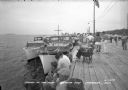
| Date: | 1940 |
|---|---|
| Description: | View of a crowd gathered along a pier for Regatta Day. Boats are docked alongside the pier on the left. |

| Date: | 1936 |
|---|---|
| Description: | This map shows campsites, trails, auto roads, surrounding townships, and points of interest, by including pictorial illustrations. Includes an inserted map... |
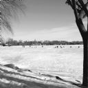
| Date: | 01 2014 |
|---|---|
| Description: | View from shoreline on a sunny day of snow-covered, frozen Monona Bay. People in the distance are standing or sitting near ice fishing holes and ice fishin... |
| Date: | 1932 |
|---|---|
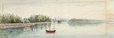
| Description: | Colorized postcard of Green Bay from Egg Harbor. A long pier with a rowboat at the side and a sailboat at the end. Caption reads: "Harbor Scene - Alpine Re... |
| Date: | 1919 |
|---|---|
| Description: | View towards shoreline with a group of people gathered at a bathing beach. Some people are in the water; other people are standing on the shore fully dress... |

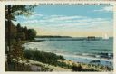
| Date: | |
|---|---|
| Description: | View from shoreline looking out towards the public beach with several bathers. Diving platforms are out in the bay. Caption reads: "Fish Creek, Wis. The Ba... |
If you didn't find the material you searched for, our Library Reference Staff can help.
Call our reference desk at 608-264-6535 or email us at: