Filter: Categories of Wisconsin Historical Images
Filter: Subject of Real estate development
Filter: Year of 1900-1999
Filter: Subject of cities and towns
Filter: Categories of Wisconsin Historical Images
Filter: Subject of Real estate development
Filter: Year of 1900-1999
Filter: Subject of cities and towns
| Date: | 12 02 1970 |
|---|---|
| Description: | An aerial view of East Towne Shopping Center (now East Towne Mall) looking southeast across East Washington Avenue. |

| Date: | 08 28 1970 |
|---|---|
| Description: | An aerial view of West Towne Shopping Center (now West Towne Mall) at Mineral Point and Gammon Roads. |

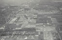
| Date: | 06 07 1954 |
|---|---|
| Description: | Aerial view of the Midvale neighborhood under construction showing the intersection of Midvale and Tokay Boulevards near the southwestern city limits of Ma... |

| Date: | 06 07 1954 |
|---|---|
| Description: | Aerial view looking north from near the city's southwestern limits in 1954. Shows text indicating Midvale Boulevard, Odana Road, Tokay Boulevard, Mineral P... |

| Date: | 1955 |
|---|---|
| Description: | Aerial view of Midvale neighborhood under construction near Madison's southwestern city limits. The view is focused on the area bounded by Tokay Boulevard,... |

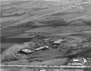
| Date: | 1958 |
|---|---|
| Description: | Aerial view of Craig Avenue and Crestwood Avenue. |
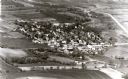
| Date: | 1909 |
|---|---|
| Description: | Illustration of town. Caption reads: "Bird's-eye View, Lyons, Wisconsin. A Village of natural environments, choice residence locations, desirable factory s... |
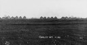
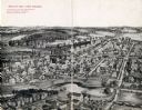
| Date: | 1901 |
|---|---|
| Description: | Thirteen unfinished houses in a row, on the horizon of a field. Captin reads: "Corliss Wis In 1901". |

| Date: | 1956 |
|---|---|
| Description: | Aerial view looking south from a point over the Maple Bluff country club golf course (foreground). A new housing development in the mid-ground and Maple Bl... |
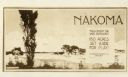
| Date: | 1927 |
|---|---|
| Description: | Postcard for Nakoma Realty Company. Caption reads: "Nakoma, You'll Enjoy The Wide Outdoors! 150 Acres Set Aside For Play! A Madison Realty Co. Property." |

| Date: | 1919 |
|---|---|
| Description: | This is a collection of three hand-colored plat maps. One map is a plat plan and includes annotations and an index that shows public land, business, indust... |

| Date: | 09 1958 |
|---|---|
| Description: | An aerial view of University Hill Farms on Madison's west side, a complete 604 acre community developed by the Regents of the University of Wisconsin. Real... |

| Date: | 12 07 1948 |
|---|---|
| Description: | Houses on the south side of the 2100 block of University Avenue. The address on the entrance at the far right is 2125. |
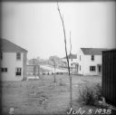
| Date: | 07 05 1938 |
|---|---|
| Description: | A recently planted sapling in the backyard of an empty house, with other houses and roads visible in the background. |
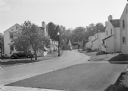
| Date: | 1936 |
|---|---|
| Description: | View from lawn of curved residential street lined with recently constructed housing and lampposts. A car sits in a driveway of a house on the left, and fur... |

| Date: | 1936 |
|---|---|
| Description: | Recently constructed residential housing as viewed from a hill. A fence is in the foreground. Porches, backyards, and small garages lead down to the Villag... |

| Date: | 1936 |
|---|---|
| Description: | View up residential street with newly constructed houses, young trees and lampposts. Men in suits and hats walk along the sidewalk. A speed limit sign is o... |
If you didn't find the material you searched for, our Library Reference Staff can help.
Call our reference desk at 608-264-6535 or email us at: