 Filter: Categories of Wisconsin Historical Images
Filter: Subject of Real estate development
Filter: Year of 1900-1999
Filter: Type of Map or Atlas
Filter: Categories of Wisconsin Historical Images
Filter: Subject of Real estate development
Filter: Year of 1900-1999
Filter: Type of Map or Atlas

| Date: | 1919 |
|---|---|
| Description: | This is a collection of three hand-colored plat maps. One map is a plat plan and includes annotations and an index that shows public land, business, indust... |

| Date: | 1914 |
|---|---|
| Description: | This map is a photostat copy from the original 1829 map in the War Department. The map shows location of Fort Howard, lots, land claims of Jacques Porlier ... |

| Date: | 1939 |
|---|---|
| Description: | This is a zoning map of Wauwatosa with a key of districts including agricultural, resident, business, commercial, and industrial. The map features labeled ... |

| Date: | 1918 |
|---|---|
| Description: | This is a collection of two maps. One map is blue line print that includes illustrations and shows the location of buildings, gardens, plant life, and spri... |

| Date: | 1900 |
|---|---|
| Description: | This photostat map was probably originally created in 1835 and shows in addition to private claims, mills, roads, and trails. Green Bay and the Fox River a... |

| Date: | 1900 |
|---|---|
| Description: | This photocopied map shows private claim owners, buildings, and land use in 1818. Insets show Fort Howard and the caption reads: "A view of the Fox River ... |
| Date: | 1900 |
|---|---|
| Description: | A map of Lake Geneva, including the villages of Williams Bay and Fontana, and a portion of the city of Lake Geneva. The Chicago and Northwestern Railway li... |

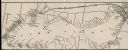
| Date: | 1920 |
|---|---|
| Description: | This bird's-eye-view map shows plat of area, numbered blocks and lots, local streets, roads, parks, golf club, schools, buildings, landscaping, and part of... |

| Date: | 1902 |
|---|---|
| Description: | This blueprint map shows land parcels, parks, blocks, and streets in the region north to Atwood Avenue, south to Lake Monona, west to Evergreen Avenue, and... |

| Date: | 1910 |
|---|---|
| Description: | This blueprint plat map shows the plan of lots and streets on a Madison hill south of Lake Monona. Includes annotations showing land prices in pencil. |

| Date: | 1915 |
|---|---|
| Description: | This map shows streets and lots with prices available through the Madison Realty Company. Some of the plats include legends. The areas include: Brooks' Add... |

| Date: | 1920 |
|---|---|
| Description: | This map shows lands owned by the American Immigration Company (red) and the Homeseekers Land Company (green). The map also shows highways, roads, railroad... |

| Date: | 1937 |
|---|---|
| Description: | This cadastral map shows lots, streets, and Pell Lake. The back of the map includes a large advertisement for the Pell Lake Addition summer home lots. |
If you didn't find the material you searched for, our Library Reference Staff can help.
Call our reference desk at 608-264-6535 or email us at:
