 Filter: Categories of Wisconsin Historical Images
Filter: Subject of Real estate development
Filter: Subject of streets
Filter: Categories of Wisconsin Historical Images
Filter: Subject of Real estate development
Filter: Subject of streets

| Date: | 1898 |
|---|---|
| Description: | University Heights from the Chemistry Building on University Avenue. View includes the University of Wisconsin-Madison football field, on the former site o... |
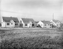
| Date: | 11 23 1938 |
|---|---|
| Description: | A row of houses at 826, 830, 834 & 838 North Fair Oaks Avenue built by the Fitzpatrick Lumber Company in what was the Town of Blooming Grove, now near East... |
| Date: | 08 26 1928 |
|---|---|
| Description: | Front view of the entrance to the North Gardens subdivision, on the corner of North Street and Hoard Street, owned by the Paul E. Stark Company. The stone ... |
| Date: | 07 26 1928 |
|---|---|
| Description: | Entrance to the North Gardens subdivision on the corner of North Street and Hoard Street, owned by Paul E. Stark Company. |

| Date: | |
|---|---|
| Description: | Poster advertising the Elmside lots for summer homes by Lake Monona. |

| Date: | 1836 |
|---|---|
| Description: | Lots to be sold at auction by Van Antwerp and Van Dyke on Monday, 3rd Oct. 1836. The map shows plots and labeled streets. Iowa County was later split and B... |

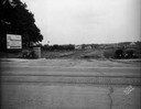
| Date: | 07 15 1957 |
|---|---|
| Description: | Cars park in a new parking lot at the former site of Washington School at 217 North Broom Street. |

| Date: | 1939 |
|---|---|
| Description: | This is a zoning map of Wauwatosa with a key of districts including agricultural, resident, business, commercial, and industrial. The map features labeled ... |

| Date: | 1874 |
|---|---|
| Description: | This map of La Crosse is accompanied by other plats of subdivision of the city. The relief is shown by hachures. The additions include: Rudolf Gripps Addit... |

| Date: | 01 31 1964 |
|---|---|
| Description: | Aerial view of University Hill Farms area which has grown from a cow pasture to a square-mile housing and business area. 4,000 people live in 750 single-fa... |

| Date: | 12 16 1964 |
|---|---|
| Description: | View of a crane about to swing a wrecking ball into a building wall at the 30 W. Mifflin Street and Carroll Street corner of the Square as a crowd is looki... |

| Date: | 1891 |
|---|---|
| Description: | This blueprint manuscript map shows land owned by Green Bay & Mississippi Canal Co., Meade, Vilas, Patten, and Hewitt. Streets and the Fox River are labele... |

| Date: | 1902 |
|---|---|
| Description: | This blueprint map shows land parcels, parks, blocks, and streets in the region north to Atwood Avenue, south to Lake Monona, west to Evergreen Avenue, and... |

| Date: | 1910 |
|---|---|
| Description: | This blueprint plat map shows the plan of lots and streets on a Madison hill south of Lake Monona. Includes annotations showing land prices in pencil. |

| Date: | 1937 |
|---|---|
| Description: | This cadastral map shows lots, streets, and Pell Lake. The back of the map includes a large advertisement for the Pell Lake Addition summer home lots. |

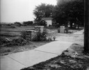
| Date: | |
|---|---|
| Description: | View across field or vacant lot of grass towards the Stanley Hanks bungalows located at 211-219 Lake Lawn Place off Langdon Street. Hanks probably built th... |

| Date: | 09 30 1953 |
|---|---|
| Description: | Six-unit apartment building at 2902 Harvey Street at Ridge Street, built in 1953. |

| Date: | 04 03 1962 |
|---|---|
| Description: | View looking south from the Shorewood bluff of the Hilldale Shopping Center under construction. Apartments and houses in the Hill Farms neighborhood are in... |
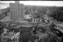
| Date: | 04 08 1957 |
|---|---|
| Description: | Elevated view from the top of central section of the State Office Building at 1 West Wilson Street, showing earth moving equipment at the excavation site f... |

| Date: | 1962 |
|---|---|
| Description: | Aerial view of the Hilldale Shopping Center and environs. Anchor store is Gimbels. N. Midvale Boulevard runs left to right. The State Department of Transpo... |
If you didn't find the material you searched for, our Library Reference Staff can help.
Call our reference desk at 608-264-6535 or email us at: