 Filter: Categories of Wisconsin Historical Images
Filter: Subject of Real estate development
Filter: Subject of recreation
Filter: Categories of Wisconsin Historical Images
Filter: Subject of Real estate development
Filter: Subject of recreation

| Date: | 1898 |
|---|---|
| Description: | University Heights from the Chemistry Building on University Avenue. View includes the University of Wisconsin-Madison football field, on the former site o... |

| Date: | 1956 |
|---|---|
| Description: | Aerial view looking south from a point over the Maple Bluff country club golf course (foreground). A new housing development in the mid-ground and Maple Bl... |
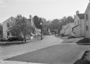
| Date: | 1936 |
|---|---|
| Description: | View from lawn of curved residential street lined with recently constructed housing and lampposts. A car sits in a driveway of a house on the left, and fur... |

| Date: | 1920 |
|---|---|
| Description: | This bird's-eye-view map shows plat of area, numbered blocks and lots, local streets, roads, parks, golf club, schools, buildings, landscaping, and part of... |
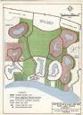
| Date: | 03 28 1964 |
|---|---|
| Description: | A master plan and land use map for East Lake Wales in Polk County, Florida showing where industrial sites, a shopping and civic center, golf course, marina... |
If you didn't find the material you searched for, our Library Reference Staff can help.
Call our reference desk at 608-264-6535 or email us at: