 Filter: Categories of Wisconsin Historical Images
Filter: Subject of Real estate development
Filter: Subject of neighborhoods
Filter: Categories of Wisconsin Historical Images
Filter: Subject of Real estate development
Filter: Subject of neighborhoods

| Date: | 1898 |
|---|---|
| Description: | University Heights from the Chemistry Building on University Avenue. View includes the University of Wisconsin-Madison football field, on the former site o... |

| Date: | 06 07 1954 |
|---|---|
| Description: | Aerial view of the Midvale neighborhood under construction showing the intersection of Midvale and Tokay Boulevards near the southwestern city limits of Ma... |
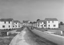
| Date: | 1936 |
|---|---|
| Description: | View down road of mass-produced residential housing with farm in background. |

| Date: | 09 1958 |
|---|---|
| Description: | An aerial view of University Hill Farms on Madison's west side, a complete 604 acre community developed by the Regents of the University of Wisconsin. Real... |

| Date: | 12 07 1948 |
|---|---|
| Description: | Houses on the south side of the 2100 block of University Avenue. The address on the entrance at the far right is 2125. |
| Date: | 02 22 1950 |
|---|---|
| Description: | Front view of a house to be used in an advertisement for home and subdivision development. The current address of this home is 3736 Sargent Street. |

| Date: | 05 03 1950 |
|---|---|
| Description: | A newly built house at 3822 John Street is shown for advertising copy for new homes sold by Roy A. Gannon Co., Realtors and built by Eugene O. Dahl. The ho... |
| Date: | 1936 |
|---|---|
| Description: | View from lawn of curved residential street lined with recently constructed housing and lampposts. A car sits in a driveway of a house on the left, and fur... |

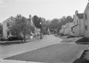
| Date: | 1936 |
|---|---|
| Description: | Recently constructed residential housing as viewed from a hill. A fence is in the foreground. Porches, backyards, and small garages lead down to the Villag... |

| Date: | 1936 |
|---|---|
| Description: | View up residential street with newly constructed houses, young trees and lampposts. Men in suits and hats walk along the sidewalk. A speed limit sign is o... |

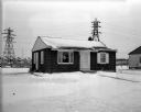
| Date: | 11 05 1954 |
|---|---|
| Description: | Front exterior view of a ranch-style house newly built by C.M. Wildenberg. The building is described as a "26'x42' three bedroom ranch." It is located at 5... |
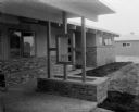
| Date: | 06 12 1956 |
|---|---|
| Description: | Planter boxes are one of the features in this house located at 5509 Russett Road. The house was built by built by Robert Shaw for the 1956 Parade of homes. |

| Date: | 07 15 1957 |
|---|---|
| Description: | Cars park in a new parking lot at the former site of Washington School at 217 North Broom Street. |

| Date: | 1918 |
|---|---|
| Description: | This is a collection of two maps. One map is blue line print that includes illustrations and shows the location of buildings, gardens, plant life, and spri... |

| Date: | 11 05 1963 |
|---|---|
| Description: | A bulldozer demolishing St. Joseph's Catholic Church at 10 South Park Street as part of the Triangle area urban renewal project. |

| Date: | 12 01 1964 |
|---|---|
| Description: | A bulldozer demolishing five homes in the four hundred block of West Washington Avenue to make room for a six-story office building to be the Wisconsin hea... |

| Date: | 1920 |
|---|---|
| Description: | This bird's-eye-view map shows plat of area, numbered blocks and lots, local streets, roads, parks, golf club, schools, buildings, landscaping, and part of... |

| Date: | 1902 |
|---|---|
| Description: | This blueprint map shows land parcels, parks, blocks, and streets in the region north to Atwood Avenue, south to Lake Monona, west to Evergreen Avenue, and... |

| Date: | 1910 |
|---|---|
| Description: | This blueprint plat map shows the plan of lots and streets on a Madison hill south of Lake Monona. Includes annotations showing land prices in pencil. |
If you didn't find the material you searched for, our Library Reference Staff can help.
Call our reference desk at 608-264-6535 or email us at:
