 Filter: Categories of Wisconsin Historical Images
Filter: Subject of Real estate development
Filter: Subject of land use
Filter: Categories of Wisconsin Historical Images
Filter: Subject of Real estate development
Filter: Subject of land use
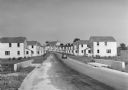
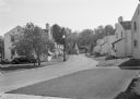
| Date: | 1936 |
|---|---|
| Description: | View down road of mass-produced residential housing with farm in background. |
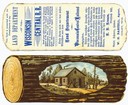
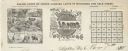
| Date: | |
|---|---|
| Description: | A colored advertising card that was issued by the Land Department of the Wisconsin Central Railroad in order to promote the sale of railroad-owned land in ... |

| Date: | 1867 |
|---|---|
| Description: | Drawn map showing planned development of Cornell, including a couple of schools, Oakwood cemetery, the public square, and several bridges and dams. |
| Date: | 06 1972 |
|---|---|
| Description: | View along the 2700 block of Fish Hatchery Road, with billboard advertising residential lots in Tower Hill Park (a development by Llyman McKee and William ... |

| Date: | 1919 |
|---|---|
| Description: | This is a collection of three hand-colored plat maps. One map is a plat plan and includes annotations and an index that shows public land, business, indust... |

| Date: | |
|---|---|
| Description: | A man wearing a tie stands next to an industrial trailer used for clearing of land. The side of the trailer reads "BROS" and there are other vehicles in th... |

| Date: | |
|---|---|
| Description: | A man in a hat and overalls leans over a trench or ditch digger, looking down into the excavated area. Pipes, an automobile, and a building are in the back... |
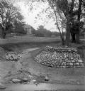
| Date: | |
|---|---|
| Description: | Rocks placed to control the flow of Dale Creek. A house is visible in the background. This picture was likely taken as a study of the water drainage in ear... |
| Date: | 1936 |
|---|---|
| Description: | View from lawn of curved residential street lined with recently constructed housing and lampposts. A car sits in a driveway of a house on the left, and fur... |

| Date: | 1936 |
|---|---|
| Description: | Recently constructed residential housing as viewed from a hill. A fence is in the foreground. Porches, backyards, and small garages lead down to the Villag... |

| Date: | 1936 |
|---|---|
| Description: | View up residential street with newly constructed houses, young trees and lampposts. Men in suits and hats walk along the sidewalk. A speed limit sign is o... |

| Date: | 1890 |
|---|---|
| Description: | Letterhead for Moulton, Moran & Co. The logo shows North America and depicts Superior as the center of a hub with spokes going to Russia, to China and Japa... |
| Date: | |
|---|---|
| Description: | Letterhead of Baldwin & Killen Lands and W.H. Killen & Company, dealers of farm, lumber, and mineral lands, from Appleton, Wisconsin, with an image on the ... |

| Date: | 1939 |
|---|---|
| Description: | This is a zoning map of Wauwatosa with a key of districts including agricultural, resident, business, commercial, and industrial. The map features labeled ... |

| Date: | 10 30 1915 |
|---|---|
| Description: | Outdoor group portrait of people identified as "settlers" (lot buyers) to the Nakoma development. Many of the people are wearing or holding a long-stemmed ... |

| Date: | 1960 |
|---|---|
| Description: | Aerial view of rural landscape with suburban construction in foreground. Cottage Grove Road is at left with the newly constructed Acewood Boulevard crossin... |

| Date: | 05 22 1954 |
|---|---|
| Description: | Madison housing development at the corner of McKenna Boulevard and Gilbert Road in the Orchard Ridge neighborhood. Shows homes, sprawling backyards and tel... |

| Date: | 04 03 1962 |
|---|---|
| Description: | View looking south from the Shorewood bluff of the Hilldale Shopping Center under construction. Apartments and houses in the Hill Farms neighborhood are in... |

| Date: | 1962 |
|---|---|
| Description: | Aerial view of the Hilldale Shopping Center and environs. Anchor store is Gimbels. N. Midvale Boulevard runs left to right. The State Department of Transpo... |
If you didn't find the material you searched for, our Library Reference Staff can help.
Call our reference desk at 608-264-6535 or email us at: