 Filter: Categories of Wisconsin Historical Images
Filter: Subject of Real estate development
Filter: Subject of botany
Filter: Categories of Wisconsin Historical Images
Filter: Subject of Real estate development
Filter: Subject of botany

| Date: | 1898 |
|---|---|
| Description: | University Heights from the Chemistry Building on University Avenue. View includes the University of Wisconsin-Madison football field, on the former site o... |
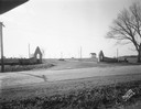
| Date: | 02 26 1930 |
|---|---|
| Description: | Entrance to Westmorland subdivision on Mineral Point Road. |
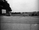
| Date: | 08 26 1928 |
|---|---|
| Description: | Front view of the entrance to the North Gardens subdivision, on the corner of North Street and Hoard Street, owned by the Paul E. Stark Company. The stone ... |
| Date: | 07 26 1928 |
|---|---|
| Description: | Entrance to the North Gardens subdivision on the corner of North Street and Hoard Street, owned by Paul E. Stark Company. |
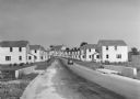
| Date: | 1936 |
|---|---|
| Description: | View down road of mass-produced residential housing with farm in background. |

| Date: | 1956 |
|---|---|
| Description: | Aerial view looking south from a point over the Maple Bluff country club golf course (foreground). A new housing development in the mid-ground and Maple Bl... |
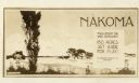
| Date: | 1927 |
|---|---|
| Description: | Postcard for Nakoma Realty Company. Caption reads: "Nakoma, You'll Enjoy The Wide Outdoors! 150 Acres Set Aside For Play! A Madison Realty Co. Property." |

| Date: | 12 07 1948 |
|---|---|
| Description: | Houses on the south side of the 2100 block of University Avenue. The address on the entrance at the far right is 2125. |

| Date: | |
|---|---|
| Description: | A man wearing a tie stands next to an industrial trailer used for clearing of land. The side of the trailer reads "BROS" and there are other vehicles in th... |
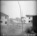
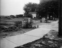
| Date: | 07 05 1938 |
|---|---|
| Description: | A recently planted sapling in the backyard of an empty house, with other houses and roads visible in the background. |
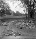
| Date: | |
|---|---|
| Description: | Rocks placed to control the flow of Dale Creek. A house is visible in the background. This picture was likely taken as a study of the water drainage in ear... |
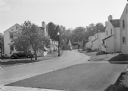
| Date: | 1936 |
|---|---|
| Description: | View from lawn of curved residential street lined with recently constructed housing and lampposts. A car sits in a driveway of a house on the left, and fur... |

| Date: | 1936 |
|---|---|
| Description: | Recently constructed residential housing as viewed from a hill. A fence is in the foreground. Porches, backyards, and small garages lead down to the Villag... |

| Date: | 1936 |
|---|---|
| Description: | View up residential street with newly constructed houses, young trees and lampposts. Men in suits and hats walk along the sidewalk. A speed limit sign is o... |
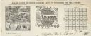
| Date: | |
|---|---|
| Description: | Letterhead of Baldwin & Killen Lands and W.H. Killen & Company, dealers of farm, lumber, and mineral lands, from Appleton, Wisconsin, with an image on the ... |
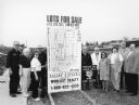
| Date: | 03 1998 |
|---|---|
| Description: | "Village officials help kick off Valley Estates Subdivision." |
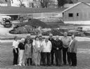
| Date: | 03 1998 |
|---|---|
| Description: | "Progress on Valley Estates Subdivision." |

| Date: | 07 15 1957 |
|---|---|
| Description: | Cars park in a new parking lot at the former site of Washington School at 217 North Broom Street. |
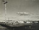
| Date: | 1960 |
|---|---|
| Description: | New residential construction on the outer southwest edge of Madison. |

| Date: | |
|---|---|
| Description: | Aerial view of Vieth's Park subdivision on the north shore of Lake Mendota. |
If you didn't find the material you searched for, our Library Reference Staff can help.
Call our reference desk at 608-264-6535 or email us at: