 Filter: Categories of Wisconsin Historical Images
Filter: Subject of Real estate development
Filter: Creator Name of Unknown
Filter: Year of 1800-1899
Filter: Categories of Wisconsin Historical Images
Filter: Subject of Real estate development
Filter: Creator Name of Unknown
Filter: Year of 1800-1899
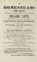
| Date: | 1855 |
|---|---|
| Description: | Advertisment of Leonard J. Farwell from the 1855 Madison City Directory for the real estate property he had for sale. At the time Farwell was the largest ... |

| Date: | 1835 |
|---|---|
| Description: | This map is pen-and-ink on paper. The map shows landowners in "Milwalky" or present day Milwaukee. Includes "list of property offered to Mr. Walker". The m... |

| Date: | 06 1837 |
|---|---|
| Description: | Pen-and-ink on paper. Shows riverside property west of the Milwaukee River. Inscribed by several early Milwaukee settlers, including Henry W. Cleveland, Cy... |

| Date: | 1891 |
|---|---|
| Description: | This blueprint manuscript map shows land owned by Green Bay & Mississippi Canal Co., Meade, Vilas, Patten, and Hewitt. Streets and the Fox River are labele... |
If you didn't find the material you searched for, our Library Reference Staff can help.
Call our reference desk at 608-264-6535 or email us at: