Filter: Categories of Wisconsin Historical Images
Filter: Subject of Real estate development
Filter: Creator Name of Unknown
Filter: Categories of Wisconsin Historical Images
Filter: Subject of Real estate development
Filter: Creator Name of Unknown
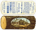
| Date: | |
|---|---|
| Description: | A colored advertising card that was issued by the Land Department of the Wisconsin Central Railroad in order to promote the sale of railroad-owned land in ... |
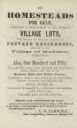
| Date: | 1855 |
|---|---|
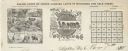
| Description: | Advertisment of Leonard J. Farwell from the 1855 Madison City Directory for the real estate property he had for sale. At the time Farwell was the largest ... |
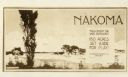
| Date: | 1927 |
|---|---|
| Description: | Postcard for Nakoma Realty Company. Caption reads: "Nakoma, You'll Enjoy The Wide Outdoors! 150 Acres Set Aside For Play! A Madison Realty Co. Property." |
| Date: | |
|---|---|
| Description: | Letterhead of Baldwin & Killen Lands and W.H. Killen & Company, dealers of farm, lumber, and mineral lands, from Appleton, Wisconsin, with an image on the ... |

| Date: | 1914 |
|---|---|
| Description: | This map is a photostat copy from the original 1829 map in the War Department. The map shows location of Fort Howard, lots, land claims of Jacques Porlier ... |

| Date: | 1835 |
|---|---|
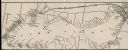
| Description: | This map is pen-and-ink on paper. The map shows landowners in "Milwalky" or present day Milwaukee. Includes "list of property offered to Mr. Walker". The m... |

| Date: | 06 1837 |
|---|---|
| Description: | Pen-and-ink on paper. Shows riverside property west of the Milwaukee River. Inscribed by several early Milwaukee settlers, including Henry W. Cleveland, Cy... |

| Date: | 1939 |
|---|---|
| Description: | This is a zoning map of Wauwatosa with a key of districts including agricultural, resident, business, commercial, and industrial. The map features labeled ... |

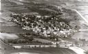
| Date: | |
|---|---|
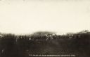
| Description: | Aerial view of Vieth's Park subdivision on the north shore of Lake Mendota. |

| Date: | 1900 |
|---|---|
| Description: | This photocopied map shows private claim owners, buildings, and land use in 1818. Insets show Fort Howard and the caption reads: "A view of the Fox River ... |
| Date: | 1900 |
|---|---|
| Description: | A map of Lake Geneva, including the villages of Williams Bay and Fontana, and a portion of the city of Lake Geneva. The Chicago and Northwestern Railway li... |

| Date: | 1891 |
|---|---|
| Description: | This blueprint manuscript map shows land owned by Green Bay & Mississippi Canal Co., Meade, Vilas, Patten, and Hewitt. Streets and the Fox River are labele... |

| Date: | 1910 |
|---|---|
| Description: | This blueprint plat map shows the plan of lots and streets on a Madison hill south of Lake Monona. Includes annotations showing land prices in pencil. |

| Date: | 1915 |
|---|---|
| Description: | This map shows streets and lots with prices available through the Madison Realty Company. Some of the plats include legends. The areas include: Brooks' Add... |

| Date: | 1937 |
|---|---|
| Description: | This cadastral map shows lots, streets, and Pell Lake. The back of the map includes a large advertisement for the Pell Lake Addition summer home lots. |

| Date: | |
|---|---|
| Description: | View across field or vacant lot of grass towards the Stanley Hanks bungalows located at 211-219 Lake Lawn Place off Langdon Street. Hanks probably built th... |
| Date: | |
|---|---|
| Description: | View toward a group o people gathered at a vacant lot. There are dwellings in the distance. Caption reads: "Lot Sale on Sub-Division, Granton, Wis." |

| Date: | 1924 |
|---|---|
| Description: | Automobiles are parked along Lincoln Road in front of the Spanish Colonial Revival style Lincoln Hotel. Two men are sitting in chairs which have the hotel'... |
If you didn't find the material you searched for, our Library Reference Staff can help.
Call our reference desk at 608-264-6535 or email us at: