Filter: Categories of Wisconsin Historical Images
Filter: Subject of Real estate development
Filter: Creator Name of Unknown
Filter: Subject of intellectual life
Filter: Categories of Wisconsin Historical Images
Filter: Subject of Real estate development
Filter: Creator Name of Unknown
Filter: Subject of intellectual life
| Date: | |
|---|---|
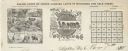
| Description: | A colored advertising card that was issued by the Land Department of the Wisconsin Central Railroad in order to promote the sale of railroad-owned land in ... |
| Date: | |
|---|---|
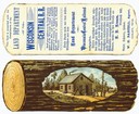
| Description: | Letterhead of Baldwin & Killen Lands and W.H. Killen & Company, dealers of farm, lumber, and mineral lands, from Appleton, Wisconsin, with an image on the ... |

| Date: | 06 1837 |
|---|---|
| Description: | Pen-and-ink on paper. Shows riverside property west of the Milwaukee River. Inscribed by several early Milwaukee settlers, including Henry W. Cleveland, Cy... |

| Date: | |
|---|---|
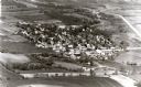
| Description: | Aerial view of Vieth's Park subdivision on the north shore of Lake Mendota. |

| Date: | 1937 |
|---|---|
| Description: | This cadastral map shows lots, streets, and Pell Lake. The back of the map includes a large advertisement for the Pell Lake Addition summer home lots. |
If you didn't find the material you searched for, our Library Reference Staff can help.
Call our reference desk at 608-264-6535 or email us at: