 Filter: Categories of Wisconsin Historical Images
Filter: Subject of Real estate business
Filter: Year of 1900-1999
Filter: Year of 1920-1929
Filter: Categories of Wisconsin Historical Images
Filter: Subject of Real estate business
Filter: Year of 1900-1999
Filter: Year of 1920-1929
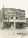
| Date: | 1925 |
|---|---|
| Description: | The Rennebohm Drug Store #1 at the corner of University Avenue and Randall Avenue, which replaced Rennebohm's first store located just across the street. A... |
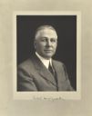
| Date: | 06 10 1921 |
|---|---|
| Description: | Quarter-length studio portrait of Arthur N. McGeoch, Milwaukee realtor. |

| Date: | 1925 |
|---|---|
| Description: | Map produced by the Paul E. Stark Company to advertising sales and services. Bottom of the map features sales records for 1919 to 1925 and a paragraph read... |

| Date: | 1925 |
|---|---|
| Description: | Map produced by the Paul E. Stark Company to advertising sales and services. Bottom of the map features sales records for 1919 to 1925 and a paragraph read... |
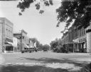
| Date: | 1929 |
|---|---|
| Description: | View down street at intersection of commercial buildings on both sides. On the left is a drug store/soda fountain, restaurant and a cafe. On the right is a... |

| Date: | 1920 |
|---|---|
| Description: | This map shows lands owned by the American Immigration Company (red) and the Homeseekers Land Company (green). The map also shows highways, roads, railroad... |
If you didn't find the material you searched for, our Library Reference Staff can help.
Call our reference desk at 608-264-6535 or email us at: