 Filter: Categories of Wisconsin Historical Images
Filter: Subject of Real estate business
Filter: Year of 1900-1999
Filter: Categories of Wisconsin Historical Images
Filter: Subject of Real estate business
Filter: Year of 1900-1999

| Date: | 1967 |
|---|---|
| Description: | Shows projects and proposed projects, some zoning districts, public housing sites (Project Wis.-3-183-4), streets, and proposed streets. Upper left hand co... |

| Date: | 1912 |
|---|---|
| Description: | View down Main Street. On the left is a bowling alley/billiard parlor, a real estate/insurance business, and a livery/garage. On the next block is City Hal... |
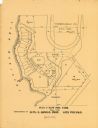
| Date: | 1900 |
|---|---|
| Description: | This maps shows part of Galesville, Trempealeau County, Wisconsin. The map shows lots for sale, local streets, and part of Lake Marinuka. Lots are numbered... |

| Date: | 04 18 1960 |
|---|---|
| Description: | Paul G. Ryan signs a lease on the Schroeder Funeral Home at 235 King Street, where he will open a new funeral home. Arthur Schroeder, present owner, looks ... |

| Date: | 1930 |
|---|---|
| Description: | View from street of the front entrance to the Lucius M. and Marion Fay home at 844 Prospect Place. The house was designed by the local firm Claude and Star... |

| Date: | 1940 |
|---|---|
| Description: | Stanley Hanks gazing at the camera while sitting in his office at 24 West Mifflin Street. There are framed photographs on the wall behind him of businesses... |

| Date: | 1959 |
|---|---|
| Description: | This map includes directories, illustrations, and an inset location map and also covers Rock, Hog, Detroit and Plum islands. |

| Date: | 1970 |
|---|---|
| Description: | This map shows land owned by Menominee Enterprise Inc., land sold to Menominee shareholders, and land sold to non-Menominees. The map also includes water a... |

| Date: | 1920 |
|---|---|
| Description: | This map shows lands owned by the American Immigration Company (red) and the Homeseekers Land Company (green). The map also shows highways, roads, railroad... |

| Date: | 1915 |
|---|---|
| Description: | This map shows roads, railroads, street railways, abandoned logging railroads, rural mail routes, telephone lines, schools, platted land, and state forest ... |

| Date: | 09 16 1953 |
|---|---|
| Description: | One and one-half story house with two dormer windows on the second level. There is a "For Sale" sign posted on house next to the front door. |

| Date: | 03 16 1954 |
|---|---|
| Description: | Single-family, one-story home for sale by Mohawk Realty in a newly built housing suburb. A telephone pole is standing behind the house on the left. There a... |

| Date: | 01 06 1955 |
|---|---|
| Description: | Commercial building at 108 and 110 North Fairchild Street. Entrances for Rider-Realty Company and Whitford Hearing Service. There is a coin-operated parkin... |

| Date: | 1973 |
|---|---|
| Description: | View across West Gilman Street towards a brick building with a decorative facade. Some of the lower windows and a door are boarded up, and a sign on the bu... |

| Date: | 1973 |
|---|---|
| Description: | View across Monona Avenue (now Martin Luther King Jr Boulevard) towards the Stark Company Realtors. The roofline has decorative urns at the corners. An aut... |

| Date: | 09 1955 |
|---|---|
| Description: | Advertisement image for a newly built, single-family, ranch-style home for sale at 4830 Tokay with four bedrooms, one and half baths, an island kitchen, an... |

| Date: | 09 1955 |
|---|---|
| Description: | Advertisement image for a one-story house at 3022 Gregory Street with three bedrooms and a first-floor laundry selling for $17,500. |

| Date: | 01 08 1958 |
|---|---|
| Description: | Group portrait of the outgoing board president of the Madison Real Estate Board with his successor and other newly installed officers. Seated are Robert ... |

| Date: | 1973 |
|---|---|
| Description: | View across East Washington towards Pyramid Realty. A car is parked outside of the building. To the right is a small parking lot, and to the left is an all... |

| Date: | 1973 |
|---|---|
| Description: | View across West Main Street, at the intersection with South Fairchild Street, towards the Fitch Block. The Fitch Block was built to match the Italianate b... |
If you didn't find the material you searched for, our Library Reference Staff can help.
Call our reference desk at 608-264-6535 or email us at: