 Filter: Categories of Wisconsin Historical Images
Filter: Subject of Real estate business
Filter: Subject of transportation
Filter: Categories of Wisconsin Historical Images
Filter: Subject of Real estate business
Filter: Subject of transportation

| Date: | |
|---|---|
| Description: | Letterhead of Christian Schroeder & Sons, a real estate, loan, and insurance agent in Milwaukee, Wisconsin, with a three-quarter view of a residence, two m... |

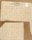
| Date: | 1903 |
|---|---|
| Description: | This map of Richland County, Wisconsin, shows land ownership and acreages, the township and range grid, sections, cities, towns and post offices, roads, ra... |
| Date: | |
|---|---|
| Description: | This 19th century manuscript map of the Town of Viroqua, Vernon County, Wisconsin, is drawn on a printed township grid. It shows landownership, roads, and ... |

| Date: | |
|---|---|
| Description: | Map shows roads, railroads, rivers, and improved farms. Includes text on lands for sale and exchange by B.W. Pulling, successor to Marshfield Land Company.... |

| Date: | 1910 |
|---|---|
| Description: | Shows land for sale by Rusk Farm Co. in Rusk and Chippewa Counties, as well as farmhouses, roads, and railroads. |

| Date: | 1891 |
|---|---|
| Description: | Map of a proposed subdivision. Map reads: "United States Investment Association SUBDIVISION No. 1 In S.W. 1/4 Sec. 33, Town 8, Range 22 East. Is situated a... |
| Date: | 1929 |
|---|---|
| Description: | View down street at intersection of commercial buildings on both sides. On the left is a drug store/soda fountain, restaurant and a cafe. On the right is a... |

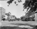
| Date: | 1967 |
|---|---|
| Description: | Shows projects and proposed projects, some zoning districts, public housing sites (Project Wis.-3-183-4), streets, and proposed streets. Upper left hand co... |

| Date: | 1890 |
|---|---|
| Description: | Shows plat of town, local streets, steam boat landings, and Chippewa River. Public square and Muskoo Island hand-colored. Map reads: "Full Lots are 125x66 ... |

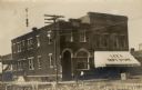
| Date: | 1912 |
|---|---|
| Description: | View down Main Street. On the left is a bowling alley/billiard parlor, a real estate/insurance business, and a livery/garage. On the next block is City Hal... |

| Date: | 1898 |
|---|---|
| Description: | This map of Duluth and Superior show lands that "will be for sale soon" in portions of Douglas County, Wisconsin and Saint Louis County, Minnesota. The map... |

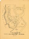
| Date: | 1836 |
|---|---|
| Description: | This map of Belmont includes notarization from the justice of the peace of Iowa County, May 15, 1836, acknowledging John Atchison as proprietor of Belmont ... |
| Date: | 1900 |
|---|---|
| Description: | This maps shows part of Galesville, Trempealeau County, Wisconsin. The map shows lots for sale, local streets, and part of Lake Marinuka. Lots are numbered... |

| Date: | |
|---|---|
| Description: | Two men sit on top of a water tank wagon which is pulled by two horses. They are posing in front of the W.H. Perrigo Veterinary Surgeon and Dentist office ... |

| Date: | 1920 |
|---|---|
| Description: | This map shows lands owned by the American Immigration Company (red) and the Homeseekers Land Company (green). The map also shows highways, roads, railroad... |

| Date: | 1915 |
|---|---|
| Description: | This map shows roads, railroads, street railways, abandoned logging railroads, rural mail routes, telephone lines, schools, platted land, and state forest ... |
| Date: | |
|---|---|
| Description: | View of a central intersection and city block with the State Bank on the corner, and Lee's Department Store (Ben C. Lee & Co.) next door on the right. A si... |

| Date: | 1973 |
|---|---|
| Description: | View across West Gilman Street towards a brick building with a decorative facade. Some of the lower windows and a door are boarded up, and a sign on the bu... |

| Date: | 1973 |
|---|---|
| Description: | View across Monona Avenue (now Martin Luther King Jr Boulevard) towards the Stark Company Realtors. The roofline has decorative urns at the corners. An aut... |

| Date: | 1973 |
|---|---|
| Description: | View across East Washington towards Pyramid Realty. A car is parked outside of the building. To the right is a small parking lot, and to the left is an all... |
If you didn't find the material you searched for, our Library Reference Staff can help.
Call our reference desk at 608-264-6535 or email us at: