 Filter: Categories of Wisconsin Historical Images
Filter: Subject of Real estate business
Filter: Subject of cities and towns
Filter: Year of 1900-1999
Filter: Categories of Wisconsin Historical Images
Filter: Subject of Real estate business
Filter: Subject of cities and towns
Filter: Year of 1900-1999
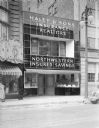
| Date: | 04 23 1937 |
|---|---|
| Description: | Haley & Sons, building facade, "Insurance, Realtors, Northwestern Insured Savings," 124 State Street. In 1940 it became home of the First Federal Savings a... |
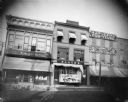
| Date: | 1900 |
|---|---|
| Description: | Looking east across Pine Street at the F. A. Schwaller Music Store / Schwaller's Real Estate Office, flanked by Theodore Riel's dry goods and grocery store... |
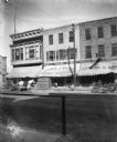
| Date: | 1900 |
|---|---|
| Description: | Looking east across Pine Street at Jacob Black's dry goods store, with a display of hand fans in front window; Schwaller's Real Estate company is above Bla... |
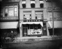
| Date: | 1900 |
|---|---|
| Description: | Looking east across Pine street at the storefronts of J. Wien's clothing, dry goods, and grocery store, Black's Dry Goods store, Schwaller's Real Estate Of... |
| Date: | 1900 |
|---|---|
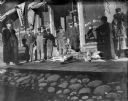
| Description: | A group of men stand in front of the Schwaller building on Pine Street with two male deer carcasses on the board sidewalk. The man touching the antlers is... |
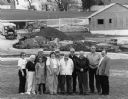
| Date: | 06 12 1956 |
|---|---|
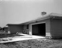
| Description: | Two-car garages are in 15 out of the 18 homes in the Parade of Homes. This home has been identified as being located at 5514 Raymond Road and built by Jose... |
| Date: | 06 12 1956 |
|---|---|
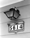
| Description: | This house in the 1956 Parade of Homes in Meadowood with its illuminated device for showing the house numbers has been wired to the exact standards of the ... |
| Date: | 06 12 1956 |
|---|---|
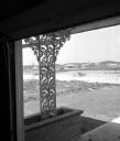
| Description: | Ornamental ironwork based in a planter holds up the corner of a roof overhang at 5609 Russett Rd. The house was built by built by Charles Fry for the 195... |

| Date: | 06 12 1956 |
|---|---|
| Description: | One of the houses in the Parade of Homes was built with a carport. This located at 5610 Raymond Rd. The house was built by built by Hermann E. Postweiler ... |

| Date: | 03 1998 |
|---|---|
| Description: | "Village officials help kick off Valley Estates Subdivision." |
| Date: | 03 1998 |
|---|---|
| Description: | "Progress on Valley Estates Subdivision." |

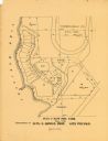
| Date: | 1903 |
|---|---|
| Description: | This map of Richland County, Wisconsin, shows land ownership and acreages, the township and range grid, sections, cities, towns and post offices, roads, ra... |

| Date: | 1910 |
|---|---|
| Description: | Shows land for sale by Rusk Farm Co. in Rusk and Chippewa Counties, as well as farmhouses, roads, and railroads. |

| Date: | 1925 |
|---|---|
| Description: | Map produced by the Paul E. Stark Company to advertising sales and services. Bottom of the map features sales records for 1919 to 1925 and a paragraph read... |

| Date: | 1925 |
|---|---|
| Description: | Map produced by the Paul E. Stark Company to advertising sales and services. Bottom of the map features sales records for 1919 to 1925 and a paragraph read... |
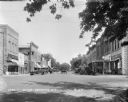
| Date: | 1929 |
|---|---|
| Description: | View down street at intersection of commercial buildings on both sides. On the left is a drug store/soda fountain, restaurant and a cafe. On the right is a... |

| Date: | 1967 |
|---|---|
| Description: | Shows projects and proposed projects, some zoning districts, public housing sites (Project Wis.-3-183-4), streets, and proposed streets. Upper left hand co... |

| Date: | 1912 |
|---|---|
| Description: | View down Main Street. On the left is a bowling alley/billiard parlor, a real estate/insurance business, and a livery/garage. On the next block is City Hal... |
| Date: | 1900 |
|---|---|
| Description: | This maps shows part of Galesville, Trempealeau County, Wisconsin. The map shows lots for sale, local streets, and part of Lake Marinuka. Lots are numbered... |

| Date: | 1959 |
|---|---|
| Description: | This map includes directories, illustrations, and an inset location map and also covers Rock, Hog, Detroit and Plum islands. |
If you didn't find the material you searched for, our Library Reference Staff can help.
Call our reference desk at 608-264-6535 or email us at: