 Filter: Categories of Wisconsin Historical Images
Filter: Subject of Real estate business
Filter: Subject of cities and towns
Filter: Categories of Wisconsin Historical Images
Filter: Subject of Real estate business
Filter: Subject of cities and towns
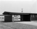
| Date: | 06 12 1956 |
|---|---|
| Description: | One of the houses in the Parade of Homes was built with a carport. This located at 5610 Raymond Rd. The house was built by built by Hermann E. Postweiler ... |

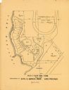
| Date: | 1899 |
|---|---|
| Description: | Map of the Santa Barbara Channel California area showing property boundaries and some geographical features. The Riven Rock Estate has been outlined in yel... |
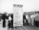
| Date: | 03 1998 |
|---|---|
| Description: | "Village officials help kick off Valley Estates Subdivision." |
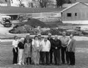
| Date: | 03 1998 |
|---|---|
| Description: | "Progress on Valley Estates Subdivision." |

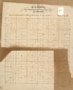
| Date: | 1903 |
|---|---|
| Description: | This map of Richland County, Wisconsin, shows land ownership and acreages, the township and range grid, sections, cities, towns and post offices, roads, ra... |
| Date: | |
|---|---|
| Description: | This 19th century manuscript map of the Town of Viroqua, Vernon County, Wisconsin, is drawn on a printed township grid. It shows landownership, roads, and ... |

| Date: | |
|---|---|
| Description: | Map shows roads, railroads, rivers, and improved farms. Includes text on lands for sale and exchange by B.W. Pulling, successor to Marshfield Land Company.... |

| Date: | 1910 |
|---|---|
| Description: | Shows land for sale by Rusk Farm Co. in Rusk and Chippewa Counties, as well as farmhouses, roads, and railroads. |

| Date: | 1925 |
|---|---|
| Description: | Map produced by the Paul E. Stark Company to advertising sales and services. Bottom of the map features sales records for 1919 to 1925 and a paragraph read... |

| Date: | 1925 |
|---|---|
| Description: | Map produced by the Paul E. Stark Company to advertising sales and services. Bottom of the map features sales records for 1919 to 1925 and a paragraph read... |
| Date: | 1929 |
|---|---|
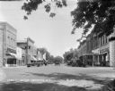
| Description: | View down street at intersection of commercial buildings on both sides. On the left is a drug store/soda fountain, restaurant and a cafe. On the right is a... |

| Date: | 1967 |
|---|---|
| Description: | Shows projects and proposed projects, some zoning districts, public housing sites (Project Wis.-3-183-4), streets, and proposed streets. Upper left hand co... |

| Date: | 1890 |
|---|---|
| Description: | Shows plat of town, local streets, steam boat landings, and Chippewa River. Public square and Muskoo Island hand-colored. Map reads: "Full Lots are 125x66 ... |

| Date: | 1912 |
|---|---|
| Description: | View down Main Street. On the left is a bowling alley/billiard parlor, a real estate/insurance business, and a livery/garage. On the next block is City Hal... |

| Date: | 1898 |
|---|---|
| Description: | This map of Duluth and Superior show lands that "will be for sale soon" in portions of Douglas County, Wisconsin and Saint Louis County, Minnesota. The map... |

| Date: | 1836 |
|---|---|
| Description: | This map of Belmont includes notarization from the justice of the peace of Iowa County, May 15, 1836, acknowledging John Atchison as proprietor of Belmont ... |
| Date: | 1900 |
|---|---|
| Description: | This maps shows part of Galesville, Trempealeau County, Wisconsin. The map shows lots for sale, local streets, and part of Lake Marinuka. Lots are numbered... |

| Date: | |
|---|---|
| Description: | Two men sit on top of a water tank wagon which is pulled by two horses. They are posing in front of the W.H. Perrigo Veterinary Surgeon and Dentist office ... |

| Date: | 1959 |
|---|---|
| Description: | This map includes directories, illustrations, and an inset location map and also covers Rock, Hog, Detroit and Plum islands. |
If you didn't find the material you searched for, our Library Reference Staff can help.
Call our reference desk at 608-264-6535 or email us at:
