 Filter: Categories of Wisconsin Historical Images
Filter: Subject of Real estate business
Filter: Subject of cities and towns
Filter: Subject of transportation
Filter: Categories of Wisconsin Historical Images
Filter: Subject of Real estate business
Filter: Subject of cities and towns
Filter: Subject of transportation
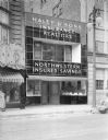
| Date: | 04 23 1937 |
|---|---|
| Description: | Haley & Sons, building facade, "Insurance, Realtors, Northwestern Insured Savings," 124 State Street. In 1940 it became home of the First Federal Savings a... |

| Date: | 1836 |
|---|---|
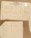
| Description: | Lots to be sold at auction by Van Antwerp and Van Dyke on Monday, 3rd Oct. 1836. The map shows plots and labeled streets. Iowa County was later split and B... |
| Date: | 1900 |
|---|---|
| Description: | Looking east across Pine Street at the F. A. Schwaller Music Store / Schwaller's Real Estate Office, flanked by Theodore Riel's dry goods and grocery store... |

| Date: | 1900 |
|---|---|
| Description: | Looking east across Pine Street at Jacob Black's dry goods store, with a display of hand fans in front window; Schwaller's Real Estate company is above Bla... |

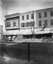
| Date: | 1900 |
|---|---|
| Description: | Looking east across Pine street at the storefronts of J. Wien's clothing, dry goods, and grocery store, Black's Dry Goods store, Schwaller's Real Estate Of... |
| Date: | |
|---|---|
| Description: | Automobiles drive past storefronts and can be seen parked on either side of Grand Avenue. Pedestrians walk on the sidewalk near the Citizens National Bank ... |

| Date: | |
|---|---|
| Description: | View down Grand Avenue. Automobiles park on either side of the avenue and drive down the street past traffic signs, stating, "Keep to the Right." On the ri... |
| Date: | |
|---|---|
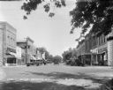
| Description: | View down East Main Street featuring several storefronts. Published by S. Friedman. |
| Date: | |
|---|---|
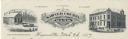
| Description: | Memohead of the Sawyer County Bank, of Hayward, Wisconsin, with the name of the bank in a banner, flanked by two images: a three-quarter view of the Real E... |
| Date: | |
|---|---|
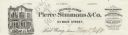
| Description: | Letterhead of the Banking House of Pierce Simmons & Company of Red Wing, Minnesota, with a view of the front of the bank building. People are walking or st... |

| Date: | |
|---|---|
| Description: | Letterhead of Christian Schroeder & Sons, a real estate, loan, and insurance agent in Milwaukee, Wisconsin, with a three-quarter view of a residence, two m... |

| Date: | 1903 |
|---|---|
| Description: | This map of Richland County, Wisconsin, shows land ownership and acreages, the township and range grid, sections, cities, towns and post offices, roads, ra... |
| Date: | |
|---|---|
| Description: | This 19th century manuscript map of the Town of Viroqua, Vernon County, Wisconsin, is drawn on a printed township grid. It shows landownership, roads, and ... |

| Date: | |
|---|---|
| Description: | Map shows roads, railroads, rivers, and improved farms. Includes text on lands for sale and exchange by B.W. Pulling, successor to Marshfield Land Company.... |

| Date: | 1910 |
|---|---|
| Description: | Shows land for sale by Rusk Farm Co. in Rusk and Chippewa Counties, as well as farmhouses, roads, and railroads. |
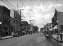
| Date: | 1929 |
|---|---|
| Description: | View down street at intersection of commercial buildings on both sides. On the left is a drug store/soda fountain, restaurant and a cafe. On the right is a... |

| Date: | 1967 |
|---|---|
| Description: | Shows projects and proposed projects, some zoning districts, public housing sites (Project Wis.-3-183-4), streets, and proposed streets. Upper left hand co... |

| Date: | 1890 |
|---|---|
| Description: | Shows plat of town, local streets, steam boat landings, and Chippewa River. Public square and Muskoo Island hand-colored. Map reads: "Full Lots are 125x66 ... |

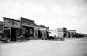
| Date: | 1912 |
|---|---|
| Description: | View down Main Street. On the left is a bowling alley/billiard parlor, a real estate/insurance business, and a livery/garage. On the next block is City Hal... |

| Date: | 1898 |
|---|---|
| Description: | This map of Duluth and Superior show lands that "will be for sale soon" in portions of Douglas County, Wisconsin and Saint Louis County, Minnesota. The map... |
If you didn't find the material you searched for, our Library Reference Staff can help.
Call our reference desk at 608-264-6535 or email us at: