 Filter: Categories of Wisconsin Historical Images
Filter: Subject of Railroads
Filter: Year of 1900-1999
Filter: Year of 1990-1999
Filter: Categories of Wisconsin Historical Images
Filter: Subject of Railroads
Filter: Year of 1900-1999
Filter: Year of 1990-1999
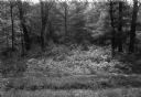
| Date: | 1997 |
|---|---|
| Description: | Black River State Forest, two miles south of US 54 in the Jackson County Forest. The sand track in the foreground is the grade of the old narrow gauge rail... |

| Date: | 1992 |
|---|---|
| Description: | This 1992 map of Wood County, Wisconsin, shows towns, sections, cities and villages, highways and roads, railroads, and lakes and streams. An inset map of ... |
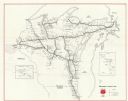
| Date: | 1990 |
|---|---|
| Description: | This map shows main railroad track, lines out of service, abandoned lines, and trackage rights. The back of the map shows Wisconsin Central Ltd. lines and ... |
| Date: | 1990 |
|---|---|
| Description: | This map shows Wisconsin Central Ltd. main track, lines out of service, abandoned lines, and trackage rights. The map covers Wisconsin and Michigan's upper... |

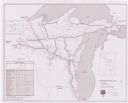
| Date: | 1997 |
|---|---|
| Description: | System map including Wisconsin Central LTD., Fox Valley and Western LTD., Algoma Central Railway, Inc., and Sault Ste. Marie Bridge Co. Detail maps at top ... |
If you didn't find the material you searched for, our Library Reference Staff can help.
Call our reference desk at 608-264-6535 or email us at: