 Filter: Categories of Wisconsin Historical Images
Filter: Subject of Railroads
Filter: Year of 1900-1999
Filter: Year of 1980-1989
Filter: Categories of Wisconsin Historical Images
Filter: Subject of Railroads
Filter: Year of 1900-1999
Filter: Year of 1980-1989
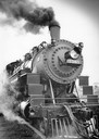
| Date: | 07 07 1984 |
|---|---|
| Description: | Steam locomotive No. 1385 moves along the tracks as part of the Butler Railroad Days. |
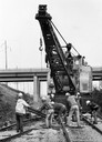
| Date: | 09 1980 |
|---|---|
| Description: | View down tracks of a repair crew working on Milwaukee Road tracks, near Rothschild, using a crane to help lift a rail. An unidentified highway bridge over... |
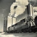
| Date: | 02 02 1988 |
|---|---|
| Description: | Two Wisconsin Central Railroad locomotives near the Consolidated Papers pulpmill at Wisconsin Rapids. Snow is on the ground, and heavy smoke is coming out ... |

| Date: | 10 30 1989 |
|---|---|
| Description: | Tommy G. Thompson, governor of Wisconsin and an enthusiastic member of the Amtrak governing board, salutes the expansion of Hiawatha service between Chicag... |
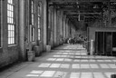
| Date: | 10 1983 |
|---|---|
| Description: | The Milwaukee Road freight car repair shop at 3301 West Canal Street. |
| Date: | 10 1983 |
|---|---|
| Description: | The Milwaukee Road sheetmetal shop, formerly formerly known as the car paint and repair shop, located at 3301 West Canal Street. |
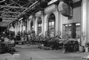
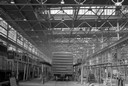
| Date: | 10 1983 |
|---|---|
| Description: | The Milwaukee Road Shops interior sheetmetal shop, formerly the car paint and repair shop, at 3301 West Canal Street. |

| Date: | 01 1983 |
|---|---|
| Description: | "This photo shows the John Steger home on the West Bend Road, foreground, the Willard Bogenschneider farm in the middle distance, and Theresa Station and t... |
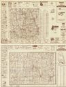
| Date: | 1984 |
|---|---|
| Description: | On verso: Map of Lafayette County, Wisconsin. Panel title. Shows roads, railroads, and highways. Includes indexes. Also includes advertisements and illustr... |

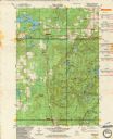
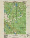
| Date: | 1982 |
|---|---|
| Description: | Color map. "Topography by photogrammetric methods from aerial photographs taken 1963. Revised from aerial photographs taken 1978. Field checked 1979. Map e... |

| Date: | 1986 |
|---|---|
| Description: | Pictorial map showing businesses with phone numbers, roads, railroads, and parks. Includes text titled: "History of Portage County." |

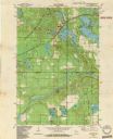
| Date: | 1982 |
|---|---|
| Description: | This standard U.S.G.S. topographic map was annotated by civil engineer and railroad historian James P. Kaysen to show the location of existing and defunct ... |

| Date: | 1980 |
|---|---|
| Description: | This map shows schools, hotels, stations, roads, railroads, reefs, and public buildings. The upper right corner includes "A Summer and Winter Guide for Spo... |
| Date: | 1982 |
|---|---|
| Description: | This standard U.S.G.S. topographic map was annotated by civil engineer and railroad historian James P. Kaysen to show the location of existing and defunct ... |
| Date: | 1982 |
|---|---|
| Description: | This standard U.S.G.S. topographic map was annotated by civil engineer and railroad historian James P. Kaysen to show the location of existing and defunct ... |
| Date: | 1982 |
|---|---|
| Description: | This standard U.S.G.S. topographic map was annotated by civil engineer and railroad historian James P. Kaysen to show the location of existing and defunct ... |
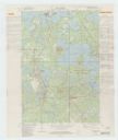
| Date: | 1982 |
|---|---|
| Description: | A map of the Hazelhurst quadrangle annotated with railroad information. |
If you didn't find the material you searched for, our Library Reference Staff can help.
Call our reference desk at 608-264-6535 or email us at: