 Filter: Categories of Wisconsin Historical Images
Filter: Subject of Railroads
Filter: Year of 1900-1999
Filter: Year of 1950-1959
Filter: Creator Name of Unknown
Filter: Categories of Wisconsin Historical Images
Filter: Subject of Railroads
Filter: Year of 1900-1999
Filter: Year of 1950-1959
Filter: Creator Name of Unknown
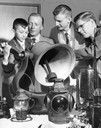
| Date: | 03 29 1958 |
|---|---|
| Description: | A young boy rings a locomotive bell. Other artifacts of locomotive history are on the table before him with members of the Milwaukee chapter of the Nationa... |
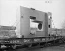
| Date: | 03 02 1956 |
|---|---|
| Description: | A seamless pipe fitting sits atop a railroad car, ready to be shipped. Later purchased and used by Elmes & Kings. Original Falk caption reads: "14' high-78... |

| Date: | 1959 |
|---|---|
| Description: | This map identifies public forest land and industrial forest land as of 1959 in Oneida County, Wisconsin, using a 1930 base map showing the township and ra... |

| Date: | 1953 |
|---|---|
| Description: | Map shows landownership and acreages, roads, and railroads in the Town of Waukesha and part of the city of Waukesha, Waukesha County, Wisconsin. |

| Date: | 05 1958 |
|---|---|
| Description: | Photocopy of a map created by the City of Milwaukee Master Plan Program City Planning Division in May of 1958 representing 1870 "THE CENTRAL AREA OF THE CI... |

| Date: | 1956 |
|---|---|
| Description: | Includes street index. Shows local streets, parks, highways, railroads, Fond du Lac River, and part of lake Winnebago. Also includes text on points of inte... |

| Date: | 1952 |
|---|---|
| Description: | Map shows roads, highways, railroads, parks, city buildings, schools, cemeteries, city limits, and the Fox River. The map is indexed by street name, street... |

| Date: | 1951 |
|---|---|
| Description: | This map of Superior shows labeled streets, waterways, railroads, and company ownership of docks. |

| Date: | 1950 |
|---|---|
| Description: | Aerial view showing shipyards, rivers and roads. |

| Date: | 1951 |
|---|---|
| Description: | This street map shows public buildings and streets. The lower left corner includes a table of street names and the middle right includes text on the street... |

| Date: | 1956 |
|---|---|
| Description: | This map shows local streets, roads, railroads, highways, parks, cemeteries, hospitals, the University of Wisconsin, Middleton, Maple Bluff, Shorewood Hill... |

| Date: | 06 02 1952 |
|---|---|
| Description: | This map shows five types of districts, as well as streets, railroads, water works buildings, and parks. The bottom left of the map has a key of district t... |

| Date: | 1952 |
|---|---|
| Description: | This map shows roads, foot and canoe trails, railroads, resorts, lookout towers, camps, national and state forests, Indian reservation, and types of fish i... |

| Date: | 1955 |
|---|---|
| Description: | This map shows roads, golf courses, airports, fire towers, schools, camp grounds, rivers, streams, lakes, and railroads. The right margin of the map includ... |
If you didn't find the material you searched for, our Library Reference Staff can help.
Call our reference desk at 608-264-6535 or email us at: