 Filter: Categories of Wisconsin Historical Images
Filter: Subject of Railroads
Filter: Year of 1900-1999
Filter: Year of 1910-1919
Filter: Year of 1918
Filter: Categories of Wisconsin Historical Images
Filter: Subject of Railroads
Filter: Year of 1900-1999
Filter: Year of 1910-1919
Filter: Year of 1918
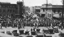
| Date: | 05 25 1918 |
|---|---|
| Description: | A crowd watching as drafted men leave Madison via the Chicago Northwestern railroad station. |

| Date: | 09 1918 |
|---|---|
| Description: | Elevated view of the U.S. Government War Exposition grounds at Grant Park. |

| Date: | 1918 |
|---|---|
| Description: | The West Madison Chicago, Milwaukee, and St. Paul railroad station, with train cars on the tracks. |

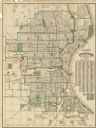
| Date: | 1918 |
|---|---|
| Description: | A map of primarily of Wisconsin, but also includes the areas of northern Illinois, eastern portions of Minnesota and Iowa, and Michigan’s Upper Peninsula, ... |

| Date: | 1918 |
|---|---|
| Description: | Men hold a sign that says "Car No. 1 Manure Secured by Y.M.C.A. for Eighth Ward War Gardens" while standing on top of a manure pile in a railroad yard. |

| Date: | 1918 |
|---|---|
| Description: | Map of Wisconsin along with the western portion of Michigan’s Upper Peninsula, showing county lines, cities and villages, lakes, streams, and railroads. Po... |
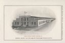
| Date: | 1918 |
|---|---|
| Description: | Illustration of the Stinson Tractor Company, located at the intersection of Central Avenue and 16th Street. The illustration was included in a booklet prod... |

| Date: | 1918 |
|---|---|
| Description: | This 1918 map of Chippewa County, Wisconsin, shows the township and range grid, towns, sections, cities and villages, rural residences, churches, schools, ... |

| Date: | 1918 |
|---|---|
| Description: | Map showing Aleppo, Zor, Syria, Lebanon, Beirut, Jerusalem, with an inset map of the Sinai Peninsula and Egyptian frontier. Also shows the locations of rai... |

| Date: | 1918 |
|---|---|
| Description: | View down railroad tracks toward a group of Russian residents working to clear another set of railroad tracks running alongside. In the far distance are tr... |
| Date: | 1918 |
|---|---|
| Description: | Elevated view of a series of three rows of large buildings, possibly used to store supplies. There are railroad tracks alongside each of the buildings. Sno... |

| Date: | 1918 |
|---|---|
| Description: | Elevated view of an Allied compound in northern Russia. There are a series of railroad tracks that are leading away from the coast. In the far distance are... |

| Date: | 1918 |
|---|---|
| Description: | A group of barracks near railroad tracks with snow in the ditch. On the far right three soldiers are walking along the railroad tracks, and other men are n... |

| Date: | 1918 |
|---|---|
| Description: | This map shows railroads, street car lines, wards, private claims, parks, railroad yards and depots, and cemeteries. The map is oriented with north to uppe... |

| Date: | 1918 |
|---|---|
| Description: | This map has relief shown by hachures and is indexed by street name and buildings. The map shows plat of town, city limits, local streets, railroads, schoo... |
| Date: | 1918 |
|---|---|
| Description: | This map shows wards, roads, railroads, parks, cemeteries, select buildings, and Lake Michigan. Also included is a street index. Cemeteries and parks are i... |

| Date: | 1918 |
|---|---|
| Description: | This map shows counties, cities, towns, villages, summer resorts, lakes, rivers, creeks, wagon roads, roads, railroads, and electric lines. The authentic a... |

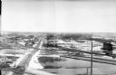
| Date: | 1918 |
|---|---|
| Description: | Aerial view of International Harvester plant. |

| Date: | 09 1918 |
|---|---|
| Description: | An insurance map of Washburn, with an index and a key. Includes a small inset map of the State of Wisconsin that shows "Location of this town as above unde... |
If you didn't find the material you searched for, our Library Reference Staff can help.
Call our reference desk at 608-264-6535 or email us at: