 Filter: Categories of Wisconsin Historical Images
Filter: Subject of Railroads
Filter: Year of 1900-1999
Filter: Year of 1910-1919
Filter: Subject of water
Filter: Categories of Wisconsin Historical Images
Filter: Subject of Railroads
Filter: Year of 1900-1999
Filter: Year of 1910-1919
Filter: Subject of water

| Date: | 1913 |
|---|---|
| Description: | Bird's-eye map of Superior. "The New Steel Center." |

| Date: | 1915 |
|---|---|
| Description: | Bird's-eye view of Superior, Wisconsin, and Duluth, Minnesota on opposite shore of Lake Superior. |

| Date: | 1910 |
|---|---|
| Description: | Bird's-eye view looking east, with Washburn Harbor at center and Chequamegon Bay in Lake Superior covering most of the upper image. Streets with buildings... |
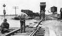
| Date: | 1915 |
|---|---|
| Description: | Four men inspecting the washout of Minneapolis, St. Paul and Sault Ste. Marie tracks caused by a flood at Medina Junction. The view is looking west from th... |

| Date: | 1911 |
|---|---|
| Description: | Plat Map of Blooming Grove in "Atlas of Dane County, Wisconsin." |

| Date: | 1915 |
|---|---|
| Description: | Elevated view of the St. Croix River, Northwest Railroad, bridge, and part of the town of Hudson. Caption reads: "Hudson, Wis. Bird's Eye View, showing St.... |

| Date: | 1911 |
|---|---|
| Description: | Elevated view of the John Gund Brewing Company buildings, with the Mississippi River in the background. Caption reads: "John Gund Brewing Co., La Crosse, W... |

| Date: | 1916 |
|---|---|
| Description: | Southeastern Wisconsin which lies east of Whitewater and south of Port Washington. |

| Date: | 1913 |
|---|---|
| Description: | Shows lands in green owned and for sale by Homeseekers Land Company, H.J. McKusick, Secretary. Map, part colored. No scale. Photographs on reverse of origi... |

| Date: | 1915 |
|---|---|
| Description: | Advertisement reads: "Castle-Pierce Printing Company" and "Feb. 1915". Text on right reads: "The Heart of Oshkosh. This birds-eye view represents about one... |

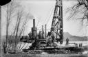
| Date: | 1911 |
|---|---|
| Description: | Workers erecting a steam driven pile driver while others survey for the railroad extension from the village of Prairie du Sac to the dam site on the Wiscon... |
| Date: | 04 1911 |
|---|---|
| Description: | Workmen pose on a steam-powered pile driver at work at the north end of the slough on the Wisconsin River. The railroad was extended from the village to th... |
| Date: | 08 15 1911 |
|---|---|
| Description: | Dam site on the Wisconsin river, looking southwest along the unfinished narrow gauge railroad trestle. The coffer dam and two pile drivers are also visible... |
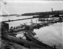
| Date: | 10 07 1911 |
|---|---|
| Description: | Elevated view of the rising waters of the Wisconsin River at the construction site. This view shows the coffer dam, pile drivers, and narrow gauge railroad... |
| Date: | 10 11 1911 |
|---|---|
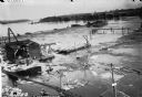
| Description: | Elevated view of high water on the Wisconsin River which has inundated the coffer dam at the construction site. The narrow gauge railroad (curved line in f... |
| Date: | 05 30 1914 |
|---|---|
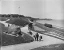
| Description: | Juneau Park looking north from approximately E. Mason Street, with the Chicago and North Western railroad tracks on the right. The Lake Michigan shoreline ... |

| Date: | 09 1918 |
|---|---|
| Description: | Elevated view of the U.S. Government War Exposition grounds at Grant Park. |
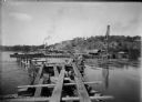
| Date: | 1910 |
|---|---|
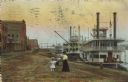
| Description: | Caption reads: "Riverfront from Pettibone Park, La Crosse, Wis." There are three steamboats docked on the right in the harbor. A mother and her children ar... |

| Date: | 1919 |
|---|---|
| Description: | This is a collection of three hand-colored plat maps. One map is a plat plan and includes annotations and an index that shows public land, business, indust... |
If you didn't find the material you searched for, our Library Reference Staff can help.
Call our reference desk at 608-264-6535 or email us at:
