 Filter: Categories of Wisconsin Historical Images
Filter: Subject of Railroads
Filter: Year of 1900-1999
Filter: Subject of land
Filter: Year of 1900-1909
Filter: Categories of Wisconsin Historical Images
Filter: Subject of Railroads
Filter: Year of 1900-1999
Filter: Subject of land
Filter: Year of 1900-1909

| Date: | 1908 |
|---|---|
| Description: | Colored map showing a panoramic view of Madison in great detail. The Wisconsin State Capitol is located at the center, with Lake Mendota in the background ... |
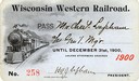
| Date: | 1900 |
|---|---|
| Description: | Pass # 258 issued to General Manager Charles Lapham by the Wisconsin Western Railroad for the year 1900. |
| Date: | 1907 |
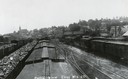
|---|---|
| Description: | Elevated view above railroad cars towards downtown Elroy. Caption reads: "Partial View Elroy Wis." |

| Date: | 1909 |
|---|---|
| Description: | [Lithography] by Poole Bros. Contains descriptive information. Short jaunts for busy people to nearby resorts in Illinois and Wisconsin. |

| Date: | 1908 |
|---|---|
| Description: | Colored map in perspective indicates railroad routes. Lake Winnebago and Oshkosh in center, area extends to Shawano (top right corner), Green Bay (bottom r... |
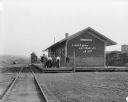
| Date: | 1909 |
|---|---|
| Description: | View from railroad tracks of a group of six people standing on the platform of the Chicago, Milwaukee and St. Paul depot. Beyond the depot is a water tower... |
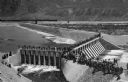
| Date: | 1903 |
|---|---|
| Description: | Elevated view of Derby Diversion Dam with a crowd gathered on the rim of the dam and individuals standing along its top. A train cuts across the horizon in... |

| Date: | 1900 |
|---|---|
| Description: | A hydrographic map of Lake Monona and the adjacent topography. |

| Date: | 1909 |
|---|---|
| Description: | Map of Sawyer County with an advertisement for land sales through Fuley & Quail of Hayward, Wisconsin. There is a small inset map of railroads accessible i... |

| Date: | 1906 |
|---|---|
| Description: | Hand-drawn topographical map of the Turville Estate. |

| Date: | 1906 |
|---|---|
| Description: | Topographical map of Turville Point and lands to the South to Nine Springs Creek. |

| Date: | 1900 |
|---|---|
| Description: | A map of Wisconsin, eastern Minnesota and Iowa, northern Iowa, and Michigan’s Upper Peninsula, showing railway lines, with those marked with heavy red line... |

| Date: | 1900 |
|---|---|
| Description: | This map, which shows the state of Wisconsin in 1895, was published as Rand, McNally & Co.'s New business atlas map of Wisconsin. Railroads, counties, citi... |

| Date: | 1900 |
|---|---|
| Description: | A map of Wisconsin, eastern Minnesota and Iowa, and Michigan’s Upper Peninsula, showing the rail lines of the Wisconsin Central Railroad are shown in red, ... |

| Date: | 1903 |
|---|---|
| Description: | A map of northern Wisconsin and Michigan showing the names and locations hunting and fishing resorts in the area, as well as location of Chicago and North ... |

| Date: | 1903 |
|---|---|
| Description: | A map that shows the location of each county, city and village in Wisconsin; in addition that maps also identifies railroads their distances between cities... |

| Date: | 1904 |
|---|---|
| Description: | A map that shows the location of the lakes and resorts in northeastern Wisconsin that were reachable by the Chicago and North Western Railway. Shown in the... |

| Date: | 1904 |
|---|---|
| Description: | A business map of Wisconsin also including the western portion of Michigan's Upper Peninsula, eastern Iowa and Minnesota, and northern Illinois, showing, r... |
If you didn't find the material you searched for, our Library Reference Staff can help.
Call our reference desk at 608-264-6535 or email us at:

