 Filter: Categories of Wisconsin Historical Images
Filter: Subject of Railroads
Filter: Year of 1900-1999
Filter: Subject of land
Filter: Creator Name of Unknown
Filter: Categories of Wisconsin Historical Images
Filter: Subject of Railroads
Filter: Year of 1900-1999
Filter: Subject of land
Filter: Creator Name of Unknown
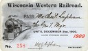
| Date: | 1900 |
|---|---|
| Description: | Pass # 258 issued to General Manager Charles Lapham by the Wisconsin Western Railroad for the year 1900. |
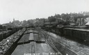
| Date: | 1907 |
|---|---|
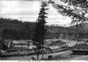
| Description: | Elevated view above railroad cars towards downtown Elroy. Caption reads: "Partial View Elroy Wis." |

| Date: | 1911 |
|---|---|
| Description: | Plat Map of Blooming Grove in "Atlas of Dane County, Wisconsin." |

| Date: | 1915 |
|---|---|
| Description: | Elevated view of the St. Croix River, Northwest Railroad, bridge, and part of the town of Hudson. Caption reads: "Hudson, Wis. Bird's Eye View, showing St.... |

| Date: | 1916 |
|---|---|
| Description: | Southeastern Wisconsin which lies east of Whitewater and south of Port Washington. |

| Date: | 1915 |
|---|---|
| Description: | Plat map of Polk township in Washington County. |
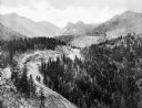
| Date: | 1930 |
|---|---|
| Description: | Elevated view of the Cripple Creek Short Line Railroad and a train winding through the mountains. |
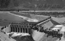
| Date: | 1903 |
|---|---|
| Description: | Elevated view of Derby Diversion Dam with a crowd gathered on the rim of the dam and individuals standing along its top. A train cuts across the horizon in... |
| Date: | 1910 |
|---|---|
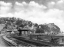
| Description: | Elevated view of the railroad shipping yards of the Idaho and Washington Northern Railway. Included in the image are numerous buildings, workers, trees, an... |

| Date: | 1911 |
|---|---|
| Description: | A map of the village of Black Earth and Verona. |

| Date: | 1931 |
|---|---|
| Description: | A map of the village of Verona, Wisconsin. |
| Date: | 1913 |
|---|---|
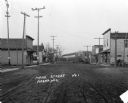
| Description: | View down of Main Street, which is a dirt street passing through the central business district of the town, featuring several storefronts with porches and ... |
| Date: | 1925 |
|---|---|
| Description: | View from the Baltimore and Ohio Railroad Station, established in 1830. The city's dwellings and establishments can be seen on a hillside from the railroa... |

| Date: | 1928 |
|---|---|
| Description: | Map of portions of Wisconsin and Minnesota between Lake Superior and Mississippi River, showing railroads and military road. |

| Date: | 1900 |
|---|---|
| Description: | A map of Wisconsin, eastern Minnesota and Iowa, northern Iowa, and Michigan’s Upper Peninsula, showing railway lines, with those marked with heavy red line... |

| Date: | 1975 |
|---|---|
| Description: | This map shows the locations of historic sites and points of interest in Rusk County, Wisconsin. A location key, descriptions of the historical importance ... |

| Date: | 1909 |
|---|---|
| Description: | A map of Langlade County, Wisconsin that shows townships and ranges, towns, cities and villages, wagon roads, churches, schools, sawmills, town halls, chee... |
If you didn't find the material you searched for, our Library Reference Staff can help.
Call our reference desk at 608-264-6535 or email us at:


