 Filter: Categories of Wisconsin Historical Images
Filter: Subject of Railroads
Filter: Year of 1900-1999
Filter: Subject of human settlements
Filter: Year of 1950-1959
Filter: Categories of Wisconsin Historical Images
Filter: Subject of Railroads
Filter: Year of 1900-1999
Filter: Subject of human settlements
Filter: Year of 1950-1959

| Date: | 09 27 1950 |
|---|---|
| Description: | Display window at Rowley & Schlimgen, 540 State Street, featuring Sheaffer's pen and pencil sets "for school days and career years" and a model trail layou... |

| Date: | 1955 |
|---|---|
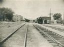
| Description: | Chicago and Northwestern Railroad (CN&W) tracks between Brearly and Ingersoll Streets. |
| Date: | 1955 |
|---|---|
| Description: | Chicago and North Western Railroad (CN&W) tracks between Brearly and Ingersoll Streets. |

| Date: | 1953 |
|---|---|
| Description: | An aerial view of Wonewoc showing central businesses and a railroad. |

| Date: | 1950 |
|---|---|
| Description: | An aerial view of town, showing a major industrial area. |
| Date: | 1952 |
|---|---|
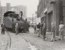
| Description: | Members of the United Packinghouse Workers Local 80 picketing the Campbell Soup Company plant. The union had walked out as a result of wage, union shop, an... |

| Date: | 1953 |
|---|---|
| Description: | A map of Lake Mendota that shows depths and the locations of various species of fish in lake. The maps also identifies a number of selected roads and stree... |

| Date: | 1959 |
|---|---|
| Description: | This map identifies public forest land and industrial forest land as of 1959 in Oneida County, Wisconsin, using a 1930 base map showing the township and ra... |

| Date: | 1952 |
|---|---|
| Description: | This map of the northern parts of the Chequamegon Bay area in Bayfield and Ashland counties, Wisconsin, shows trails, roads, railroads, stations, the towns... |

| Date: | 1956 |
|---|---|
| Description: | This 1956 map shows sections, cities and villages, roads, railroads, and lakes and streams in the Eagle River area. All or part of the towns of Plum Lake, ... |

| Date: | 1955 |
|---|---|
| Description: | This 1950s tourist brochure features a map of Burnett County, Wisconsin, and northern Polk County which shows highways and roads, railroads, landmarks, and... |

| Date: | 1953 |
|---|---|
| Description: | Map shows landownership and acreages, roads, and railroads in the Town of Waukesha and part of the city of Waukesha, Waukesha County, Wisconsin. |

| Date: | 02 1956 |
|---|---|
| Description: | This 1956 map of Waukesha County, Wisconsin, shows the township and range grid, towns, sections, cities and villages, roads, railroads, dams, airports, par... |

| Date: | 1953 |
|---|---|
| Description: | This mid 20th century map of Vilas County and northeastern Oneida County, Wisconsin, shows the township and range grid, sections, cities and villages, rail... |

| Date: | 1956 |
|---|---|
| Description: | Shows roads, railroads, highways, boundaries, and other public facilities and areas. Includes location map and legend. "Corrected for Feb. 1956." "Correcte... |

| Date: | 05 1958 |
|---|---|
| Description: | Photocopy of a map created by the City of Milwaukee Master Plan Program City Planning Division in May of 1958 representing 1870 "THE CENTRAL AREA OF THE CI... |

| Date: | 1956 |
|---|---|
| Description: | Includes street index. Shows local streets, parks, highways, railroads, Fond du Lac River, and part of lake Winnebago. Also includes text on points of inte... |

| Date: | 1956 |
|---|---|
| Description: | Includes street index and index to points of interest. Shows land ownership by name, plat of town, local streets, schools, parks, highways, railroads, ward... |
| Date: | 1959 |
|---|---|
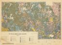
| Description: | Map of soil in Oneida County. Bottom of the map includes a legend of soil; "SECOND CLASS SOILS GOOD TO FAIR FARM LAND" are represented in shades of yellow ... |

| Date: | 1952 |
|---|---|
| Description: | Map shows roads, highways, railroads, parks, city buildings, schools, cemeteries, city limits, and the Fox River. The map is indexed by street name, street... |
If you didn't find the material you searched for, our Library Reference Staff can help.
Call our reference desk at 608-264-6535 or email us at: