Filter: Categories of Wisconsin Historical Images
Filter: Subject of Railroads
Filter: Year of 1900-1999
Filter: County of Sawyer
Filter: Categories of Wisconsin Historical Images
Filter: Subject of Railroads
Filter: Year of 1900-1999
Filter: County of Sawyer

| Date: | 1919 |
|---|---|
| Description: | This is a collection of three hand-colored plat maps. One map is a plat plan and includes annotations and an index that shows public land, business, indust... |

| Date: | 1909 |
|---|---|
| Description: | Map of Sawyer County with an advertisement for land sales through Fuley & Quail of Hayward, Wisconsin. There is a small inset map of railroads accessible i... |

| Date: | 1920 |
|---|---|
| Description: | This map of Sawyer County, Wisconsin, from the early 20th century shows the township and range system, towns, sections, cities and villages, railroads, hig... |

| Date: | 1900 |
|---|---|
| Description: | This map of Sawyer County, Wisconsin, shows the numbered "sub-school-districts of the town of Hayward" school houses, and the Indian reservation. The towns... |

| Date: | 1911 |
|---|---|
| Description: | This 1911 map of south central Sawyer County, Wisconsin, shows land for sale by Veness & Kasl of Exeland, the township and range system, sections, homes, r... |

| Date: | 1919 |
|---|---|
| Description: | This 1919 map of Sawyer County, Wisconsin, shows the township and range system, sections, cities and villages, roads, railroads, farm houses, the Indian re... |

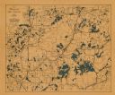
| Date: | 1925 |
|---|---|
| Description: | This 1925 map of the northern portion of Sawyer County, Wisconsin, shows the township and range system, sections, roads, railroads, and lakes and streams i... |

| Date: | 1927 |
|---|---|
| Description: | This 1927 map of Sawyer County, Wisconsin, shows the township and range system, sections, cities and villages, roads, railroads, and lakes and streams. |
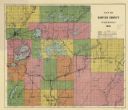
| Date: | 1931 |
|---|---|
| Description: | This 1931 map of Sawyer County, Wisconsin, shows the township and range system, towns, sections, cities and villages, railroads, highways and roads, and la... |
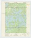
| Date: | 1940 |
|---|---|
| Description: | This map shows cities and villages, roads, railroads, and lakes and streams in northern Sawyer, northeastern Washburn, southeastern Douglas, and southern B... |

| Date: | 1915 |
|---|---|
| Description: | This map shows a plat of city, wards, sections, land ownership by name, local streets, roads, railroads, local businesses, schools, and parks. This map is ... |

| Date: | 1911 |
|---|---|
| Description: | This map shows lakes, rivers, swamps, state swamp land, trails and railroads. Includes a township diagram. |

| Date: | 1940 |
|---|---|
| Description: | This blue line print map traced from aerial survey mosaic shows reservation boundary, roads, trails, and railroads. Color manuscript annotations show triba... |

| Date: | 1906 |
|---|---|
| Description: | A diagram of Township No 37 Range No 8 in Sawyer County. |
If you didn't find the material you searched for, our Library Reference Staff can help.
Call our reference desk at 608-264-6535 or email us at: