 Filter: Categories of Wisconsin Historical Images
Filter: Subject of Railroads
Filter: Year of 1900-1999
Filter: Creator Name of Unknown
Filter: Year of 1930-1939
Filter: Categories of Wisconsin Historical Images
Filter: Subject of Railroads
Filter: Year of 1900-1999
Filter: Creator Name of Unknown
Filter: Year of 1930-1939
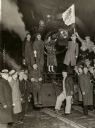
| Date: | 04 07 1933 |
|---|---|
| Description: | Schlitz train and group of revelers, celebrating the end of prohibition in Milwaukee. Schlitz Engine #8027 departs to deliver the first Schlitz beer at 12:... |
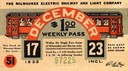
| Date: | 1933 |
|---|---|
| Description: | Pass issued by the Milwaukee Electric Railway and Light Company for the week of December 17-23, 1933. |
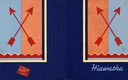
| Date: | 1930 |
|---|---|
| Description: | Menu of the Chicago, Milwaukee, St. Paul, and Pacific Railroads Hiawatha Line opened to show both the front and back cover. During the 1930s the Milwaukee ... |

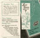
| Date: | 1935 |
|---|---|
| Description: | Color brochure advertising the Chicago, Milwaukee, St. Paul & Minneapolis Railroad's Hiawatha, the first streamlined steam locomotive. Hiawatha trains boas... |

| Date: | 1930 |
|---|---|
| Description: | Aerial view of the city and the river. |

| Date: | 1935 |
|---|---|
| Description: | An aerial view of numerous Manitowoc factories/industries. |
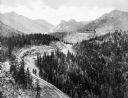
| Date: | 1930 |
|---|---|
| Description: | Elevated view of the Cripple Creek Short Line Railroad and a train winding through the mountains. |

| Date: | 1931 |
|---|---|
| Description: | A map of the village of Verona, Wisconsin. |

| Date: | 1938 |
|---|---|
| Description: | This map shows lakes, rivers, roads, trails, lookout towers, and railroads. |

| Date: | 1930 |
|---|---|
| Description: | This pictorial map from the first half of the 20th century shows the landmarks, highways, rail lines, and cities and villages in the vicinity of the Wiscon... |

| Date: | 1930 |
|---|---|
| Description: | Map of Ripon, Wisconsin. In the lower left hand corner is a list of points of interest that correspond with numbers on the map. Streets and Mill Pond are l... |

| Date: | 1931 |
|---|---|
| Description: | This map of Ashland shows roads, railroads, and local businesses. The map reads: "Showing streets and roads open to the public Oct. 1, 1931." Included on t... |

| Date: | 1932 |
|---|---|
| Description: | This map of Beaver Dam shows new boundary lines for wards, existing wards, roads, railroads, and rivers. Roads and Beaver Dam Lake are labeled. There are s... |

| Date: | 1930 |
|---|---|
| Description: | This map has relief shown pictorially and shows plat of the city, block numbers, land ownership by name, local streets, railroads, mill pond, and part of G... |

| Date: | 1930 |
|---|---|
| Description: | This map shows a plat of the town, local streets, railroads, creeks, part of Fox River, and part of the bay of Green Bay. The location of the original fort... |
| Date: | 1934 |
|---|---|
| Description: | Leaflet with sample menu and an illustration of a tall cold drink, behind which other dishes hold steaming hot food. The interior of the leaflet has an ill... |

| Date: | 1930 |
|---|---|
| Description: | This map shows city wards, streets, railroads, parks, Lake Butte Des Morts, Lake Winnebago, advertisements for Dixie Oils Gasoline, a list of Cook & Brown ... |

| Date: | 1933 |
|---|---|
| Description: | This blueprint map shows lakes, roads, railroads, townships and sections. A legend is also included that shows highway surface types. |
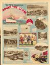
| Date: | 11 23 1930 |
|---|---|
| Description: | Full page illustrated article in the Milwaukee Journal titled "The World Voyagers go Round The Globe by Radio and Roto." Included are photographs an... |

| Date: | 1937 |
|---|---|
| Description: | Map showing territory controlled by the Finches, a family of bandits who terrorized south central Wisconsin in the years prior to the Civil War. The map in... |
If you didn't find the material you searched for, our Library Reference Staff can help.
Call our reference desk at 608-264-6535 or email us at: