 Filter: Categories of Wisconsin Historical Images
Filter: Subject of Railroads
Filter: Year of 1900-1999
Filter: Type of Map or Atlas
Filter: Categories of Wisconsin Historical Images
Filter: Subject of Railroads
Filter: Year of 1900-1999
Filter: Type of Map or Atlas

| Date: | 1900 |
|---|---|
| Description: | A map of Wisconsin, eastern Minnesota and Iowa, northern Iowa, and Michigan’s Upper Peninsula, showing railway lines, with those marked with heavy red line... |

| Date: | 1900 |
|---|---|
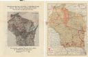
| Description: | This map, which shows the state of Wisconsin in 1895, was published as Rand, McNally & Co.'s New business atlas map of Wisconsin. Railroads, counties, citi... |

| Date: | 1900 |
|---|---|
| Description: | A map of Wisconsin, eastern Minnesota and Iowa, and Michigan’s Upper Peninsula, showing the rail lines of the Wisconsin Central Railroad are shown in red, ... |

| Date: | 1903 |
|---|---|
| Description: | A map of northern Wisconsin and Michigan showing the names and locations hunting and fishing resorts in the area, as well as location of Chicago and North ... |

| Date: | 1903 |
|---|---|
| Description: | A map that shows the location of each county, city and village in Wisconsin; in addition that maps also identifies railroads their distances between cities... |

| Date: | 1904 |
|---|---|
| Description: | A map that shows the location of the lakes and resorts in northeastern Wisconsin that were reachable by the Chicago and North Western Railway. Shown in the... |

| Date: | 1904 |
|---|---|
| Description: | A business map of Wisconsin also including the western portion of Michigan's Upper Peninsula, eastern Iowa and Minnesota, and northern Illinois, showing, r... |

| Date: | 1908 |
|---|---|
| Description: | A business map of Wisconsin, showing railroads, counties, cities, villages, rivers, and lakes. Additional areas shown in the map include the western portio... |

| Date: | 1908 |
|---|---|
| Description: | A map of Wisconsin showing cities and towns, rivers, lakes, and railroads. Other areas included in the map are the western portion of Michigan's Upper Pen... |

| Date: | 1909 |
|---|---|
| Description: | A brochure with a map showing the North-Western Railway lines from northern Illinois, starting at Chicago, to southeastern Wisconsin, stopping at Sheboygan... |

| Date: | 1910 |
|---|---|
| Description: | A business map of Wisconsin, showing railroads, counties, cities, villages, rivers, lakes, and electric lines. Additional areas also included in the map ar... |

| Date: | 1911 |
|---|---|
| Description: | A business atlas map of Wisconsin, showing the railroads, counties, cities, villages, rivers, lakes, electric lines, and steamship lines in the state. Othe... |

| Date: | 1913 |
|---|---|
| Description: | A hand-colored map of Wisconsin and portions of eastern Iowa and Minnesota, northern Illinois, and the western part of Michigan’s Upper Peninsula, showing ... |

| Date: | 1914 |
|---|---|
| Description: | Two maps of northern Wisconsin counties of Ashland, Barron, Bayfield, Chippewa, Douglas, Forest, Iron, Langlade, Lincoln, Oneida, Polk, Price, Sawyer, Tayl... |

| Date: | 1914 |
|---|---|
| Description: | A hand-colored map of Wisconsin showing the locations of cities and towns, counties, railway lines, the steamship lines in Lake Superior and lake Michigan.... |

| Date: | 1918 |
|---|---|
| Description: | Map of Wisconsin along with the western portion of Michigan’s Upper Peninsula, showing county lines, cities and villages, lakes, streams, and railroads. Po... |

| Date: | 1941 |
|---|---|
| Description: | A map of the area south of Ripon and Sheboygan and east of Waterloo and Janesville, showing the route of the Chicago, North Shore and Milwaukee Railroad in... |
| Date: | 1910 |
|---|---|
| Description: | Two maps that show the rail lines of the Minneapolis, St. Paul & Sault Ste. Marie Railway Company in Wisconsin. The first map shows these lines on the Map ... |

| Date: | 1943 |
|---|---|
| Description: | A map that shows the lands for sale by the Tomahawk Land Company of Tomahawk, Wisconsin, in the counties of Langlade, Lincoln, Oneida, and Price. The map s... |

| Date: | 1939 |
|---|---|
| Description: | This map shows the towns to Gingles, Sanborn, and Guney as well as Chequamegon Bay, Kakagon River, White River, Marengo River, Bad River, Potato River, Vau... |
If you didn't find the material you searched for, our Library Reference Staff can help.
Call our reference desk at 608-264-6535 or email us at: