Filter: Categories of Wisconsin Historical Images
Filter: Subject of Railroads
Filter: Year of 1800-1899
Filter: Categories of Wisconsin Historical Images
Filter: Subject of Railroads
Filter: Year of 1800-1899
| Date: | 12 23 1895 |
|---|---|
| Description: | Horse-drawn implement makes a cut at a crossing where the tunnel will be made for the Wisconsin Central Railway. |
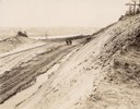
| Date: | 12 11 1895 |
|---|---|
| Description: | View of the construction area of the Wisconsin Central Railway, looking southeast at Shipyard Point with workers and a team of horses. |
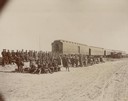
| Date: | 10 1898 |
|---|---|
| Description: | A cavalry troop from the Ojibwa-Pillager Battle at Sugar Point on Bear Island gathers near a train. |

| Date: | 1856 |
|---|---|
| Description: | Wisconsin map illustrating the Mineral Point Railroad and its connections. |

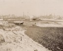
| Date: | 1876 |
|---|---|
| Description: | Elevated view showing Elmore and Kelly's Elevator with a boat, train, and the buildings at Fort Howard. Fort Howard was incorporated into Green Bay. Captio... |

| Date: | 1889 |
|---|---|
| Description: | Chicago, Milwaukee & St. Paul passenger depot with several people standing in front of the building. This is the Franklin Street station on East Wilson Str... |

| Date: | 1889 |
|---|---|
| Description: | Original Chicago & North Western Railroad passenger station, 219 South Blair Street at East Wilson Street, with a few men gathered out front. Torn down in... |
| Date: | 1891 |
|---|---|
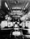
| Description: | Interior view of the Pullman sleeping car "Pioneer," which is arranged for daytime use, and showing the richly ornamented paneling and painted ceiling. Thi... |
| Date: | 1893 |
|---|---|
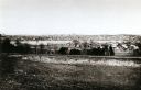
| Description: | View from the south, with a railroad in the foreground, a river in the middle distance, and Janesville in the background. |

| Date: | 1890 |
|---|---|
| Description: | Left half of a plat map of the "East Part of the city of Madison". |

| Date: | 1890 |
|---|---|
| Description: | Right side of a plat map of the "East Part of the City of Madison". |

| Date: | 1885 |
|---|---|
| Description: | Illustrated view of Superior, as well as Omaha, Kansas City, St. Paul, and Winnipeg. Caption reads: "Superior - The Last Possible Great Marine City in the ... |
| Date: | 1857 |
|---|---|
| Description: | One thousand dollar bond and unclipped coupons issued by the city of Madison in 1857. The bond was illustrated with a railroad train, perhaps to suggest th... |

| Date: | 1855 |
|---|---|
| Description: | Map of the city of Madison, Dane County, published by George Harrison, surveyed and drawn by P. McCabe, and engraved by J.H. Colton & Co., New York. In add... |
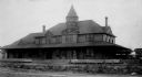
| Date: | 1895 |
|---|---|
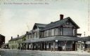
| Description: | View across railroad tracks towards the Wisconsin Central railroad station. Caption reads: "Soo Line Passenger Depot, Stevens Point, Wis." |
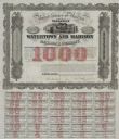
| Date: | 1857 |
|---|---|
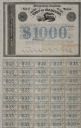
| Description: | One thousand dollar bond and coupons issued by the Watertown and Madison Railroad Company in 1857. Jairus Fairchild, president, and T.L. Lawrence have sig... |
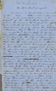
| Date: | 1857 |
|---|---|
| Description: | Draft newspaper editorial, "Our Railroad Prospects," written by former governor Leonard J. Farwell. |
If you didn't find the material you searched for, our Library Reference Staff can help.
Call our reference desk at 608-264-6535 or email us at: