Filter: Categories of Wisconsin Historical Images
Filter: Subject of Railroads
Filter: Subject of water
Filter: Categories of Wisconsin Historical Images
Filter: Subject of Railroads
Filter: Subject of water
| Date: | 1901 |
|---|---|
| Description: | Lithographed poster depicting an elevated view of the Warder, Bushnell, and Glessner factory and surrounding area. Text in the upper left corner reads, "Ch... |
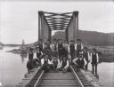
| Date: | 1890 |
|---|---|
| Description: | A railroad section crew poses with a handcar on the trestle spanning the Buffalo River, north of Alma, Wisconsin. |
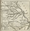
| Date: | |
|---|---|
| Description: | Map of Missouri with major cities, rivers, and railroads marked. |

| Date: | 1913 |
|---|---|
| Description: | A wall atlas of Sauk County, Wisconsin, displaying its 22 towns. On the left side are advertisements for local businesses. |

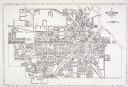
| Date: | 1931 |
|---|---|
| Description: | A map of the village of Verona, Wisconsin. |

| Date: | 1877 |
|---|---|
| Description: | Map of northern Wisconsin showing the lands owned by Cornell University (shaded portions) in 1877. The map depicts the lakes, river systems, towns, and th... |
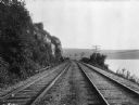
| Date: | |
|---|---|
| Description: | View of Chicago, Northwestern Railroad set of two railroad tracks at Devil's Lake, chartered in 1859. To the right, power lines run the length of the Devil... |

| Date: | 1930 |
|---|---|
| Description: | Pictorial map of Glacier National Park, Montana and Waterton Lakes National Park, Alberta. Illustrated by Joe Scheurle, it depicts white people, American ... |
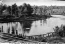
| Date: | |
|---|---|
| Description: | View of the Flambeau River from Soo Bridge. The railroad bridges crosses over the river and foliage lines the riverbanks. |

| Date: | 1866 |
|---|---|
| Description: | View along earthworks overlooking the Etawah River and a railroad bridge. A tree stripped of branches and bark is on the left. Plate 23 |

| Date: | 1918 |
|---|---|
| Description: | A map of primarily of Wisconsin, but also includes the areas of northern Illinois, eastern portions of Minnesota and Iowa, and Michigan’s Upper Peninsula, ... |

| Date: | |
|---|---|
| Description: | A railroad bridge crosses over Red Cedar River. |

| Date: | |
|---|---|
| Description: | Map of Baraboo and its surroundings, showing the ancient mound city, the water power, and thoroughfares, drawn by William H. Canfield. Canfield includes sk... |
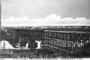
| Date: | |
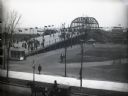
|---|---|
| Description: | Elevated view of the Wisconsin Central Railroad Bridge. Wisconsin Central Railroad Company was incorporated in February 1871. Caption reads: "Wisconsin Cen... |

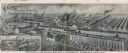
| Date: | 1902 |
|---|---|
| Description: | Two panoramic bird's-eye views of the Paine Lumber Company, including the general plant, sawmill, and lumber yards. Heading at the top says: Home of Wiscon... |

| Date: | 1847 |
|---|---|
| Description: | A color map of Kentucky with insets showing Lexington, the Falls of Ohio, and the Ohio River. |
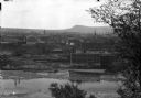
| Date: | |
|---|---|
| Description: | Elevated view of town buildings as seen from Bancroft Tower. A body of water and what appears to be an industrial plant are in the foreground. |
| Date: | 1893 |
|---|---|
| Description: | Elevated view of the Illinois Central World's Fair Transportation Center at Van Buren Street. Several pedestrians cross a bridge leading to trains and lake... |
If you didn't find the material you searched for, our Library Reference Staff can help.
Call our reference desk at 608-264-6535 or email us at: