 Filter: Categories of Wisconsin Historical Images
Filter: Subject of Railroads
Filter: Subject of water
Filter: Categories of Wisconsin Historical Images
Filter: Subject of Railroads
Filter: Subject of water

| Date: | 1882 |
|---|---|
| Description: | The official railroad map of Wisconsin showing railroad lines throughout the state. |

| Date: | 1884 |
|---|---|
| Description: | The official railroad map of Wisconsin showing railroad lines throughout the state. |

| Date: | |
|---|---|
| Description: | View of the Burlington Northern Santa Fe Railroad Bridge spanning the Columbia River, connecting Vancouver, Washington, with Portland, Oregon. Caption read... |

| Date: | |
|---|---|
| Description: | Elevated view of the camp and valley of the site of the Elephant Butte Dam near Truth or Consequences. There are buildings, roads, railroad tracks, and tra... |

| Date: | 1896 |
|---|---|
| Description: | Section 5 of 12, this bicycle road map features Wisconsin bicycle routes in the counties of La Crosse, Monroe, Vernon, Crawford, Richland, Sauk, Juneau, an... |
| Date: | 1903 |
|---|---|
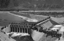
| Description: | Elevated view of Derby Diversion Dam with a crowd gathered on the rim of the dam and individuals standing along its top. A train cuts across the horizon in... |

| Date: | |
|---|---|
| Description: | View of Rock Island Pond, with a telephone pole in the foreground, and railroad tracks leading off into the distance. In the distance is a farm or manufact... |
| Date: | |
|---|---|
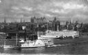
| Description: | Elevated view of the two steamships, including the James T. Brett, on the Hudson River, with the central business district of the city in the background. |
| Date: | |
|---|---|
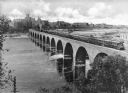
| Description: | Elevated view of an Oriental Limited train crossing The Stone Arch Bridge over a river. The bridge was built by The Great Northern Railway in 1883. There i... |

| Date: | |
|---|---|
| Description: | Elevated distant view of the town of Medicine Hat, Alberta and a Canadian Pacific Railway Bridge. Caption reads: "General View of Medicine Hat, Alta. Showi... |

| Date: | |
|---|---|
| Description: | Elevated view of the city, which includes a factory, numerous buildings, railroad tracks, a bridge, Elizabeth river, and hills in the background. |

| Date: | 1863 |
|---|---|
| Description: | A map of Illinois showing all railroads, stations, and towns. |

| Date: | 1896 |
|---|---|
| Description: | A map of the Chain-O-Lakes in Waupaca, including Indian trails. The path of the Waupaca Electric Railway from the Grand View Hotel to the Wisconsin Central... |

| Date: | 1856 |
|---|---|
| Description: | A Wisconsin map showing the Wisconsin Superior and St. Croix Railroad. |

| Date: | 1900 |
|---|---|
| Description: | A hydrographic map of Lake Monona and the adjacent topography. |

| Date: | 1911 |
|---|---|
| Description: | A map of the village of Black Earth and Verona. |

| Date: | |
|---|---|
| Description: | Elevated view of a small settlement between two mountains and alongside a river with tracks of the first transcontinental railroad passing through. A bridg... |
| Date: | |
|---|---|
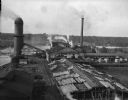
| Description: | Elevated view of the Brooks Scanlon Company, which specialized in lumber. The complex sits on a river. The lumber is lying out on the tops of roofs and in ... |
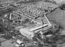
| Date: | 1920 |
|---|---|
| Description: | Aerial view of the Baldwin Lumber Company, which sits next to a river. The main building consists of two long, rectangular structures that sit perpendicula... |
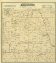
| Date: | 1873 |
|---|---|
| Description: | Columbia County Atlas Arlington Township 10 North Range 9 East. |
If you didn't find the material you searched for, our Library Reference Staff can help.
Call our reference desk at 608-264-6535 or email us at: