 Filter: Categories of Wisconsin Historical Images
Filter: Subject of Railroads
Filter: Subject of water
Filter: Categories of Wisconsin Historical Images
Filter: Subject of Railroads
Filter: Subject of water

| Date: | 1909 |
|---|---|
| Description: | [Lithography] by Poole Bros. Contains descriptive information. Short jaunts for busy people to nearby resorts in Illinois and Wisconsin. |

| Date: | |
|---|---|
| Description: | Plat map of the east central part of the city. |

| Date: | 1882 |
|---|---|
| Description: | This basic reference map of the state shows natural features, railroads, county seats, and political boundaries against the G.L.O. township and range grid.... |

| Date: | 1868 |
|---|---|
| Description: | Showing the counties, towns and railroads. Partly colored. Scale: 1 inch = 20 miles. |

| Date: | 1898 |
|---|---|
| Description: | Shows railway lines in Wisconsin marked in red and counties in colors. The meridians are Greenwich, Wisconsin and Washington, Wisconsin. The map folds into... |

| Date: | 1859 |
|---|---|
| Description: | This 1859 railroad map shows counties, cities, rivers and lakes in the entire state of Wisconsin. It includes an inset depicting the railroads in Milwaukee... |

| Date: | 1916 |
|---|---|
| Description: | Southeastern Wisconsin which lies east of Whitewater and south of Port Washington. |

| Date: | 1913 |
|---|---|
| Description: | Shows lands in green owned and for sale by Homeseekers Land Company, H.J. McKusick, Secretary. Map, part colored. No scale. Photographs on reverse of origi... |

| Date: | 1908 |
|---|---|
| Description: | Colored map in perspective indicates railroad routes. Lake Winnebago and Oshkosh in center, area extends to Shawano (top right corner), Green Bay (bottom r... |

| Date: | |
|---|---|
| Description: | View from hill towards the elevated Chicago, St. Paul, Minneapolis and Omaha railroad bridge over the Chippewa River at Eau Claire. |

| Date: | 1850 |
|---|---|
| Description: | [... through northern United States from New York to Minnesota]. Lithography by T. Sinclair. From Perrault papers, Lucien S. Hanks, donor. |

| Date: | 1853 |
|---|---|
| Description: | Shows railroads, planned and in place. |

| Date: | 1887 |
|---|---|
| Description: | Benedict & Co. engineers. As shown by development to March 1st 1887. Inset: Map of northern Wisconsin showing location of range. Lands in red. |

| Date: | 1915 |
|---|---|
| Description: | Advertisement reads: "Castle-Pierce Printing Company" and "Feb. 1915". Text on right reads: "The Heart of Oshkosh. This birds-eye view represents about one... |

| Date: | 1911 |
|---|---|
| Description: | Workers erecting a steam driven pile driver while others survey for the railroad extension from the village of Prairie du Sac to the dam site on the Wiscon... |
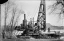
| Date: | 04 1911 |
|---|---|
| Description: | Workmen pose on a steam-powered pile driver at work at the north end of the slough on the Wisconsin River. The railroad was extended from the village to th... |
| Date: | 08 15 1911 |
|---|---|
| Description: | Dam site on the Wisconsin river, looking southwest along the unfinished narrow gauge railroad trestle. The coffer dam and two pile drivers are also visible... |
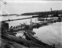
| Date: | 10 07 1911 |
|---|---|
| Description: | Elevated view of the rising waters of the Wisconsin River at the construction site. This view shows the coffer dam, pile drivers, and narrow gauge railroad... |
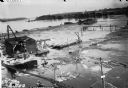
| Date: | 10 11 1911 |
|---|---|
| Description: | Elevated view of high water on the Wisconsin River which has inundated the coffer dam at the construction site. The narrow gauge railroad (curved line in f... |
If you didn't find the material you searched for, our Library Reference Staff can help.
Call our reference desk at 608-264-6535 or email us at:
