Filter: Categories of Wisconsin Historical Images
Filter: Subject of Railroads
Filter: Subject of transportation
Filter: Subject of rivers
Filter: Categories of Wisconsin Historical Images
Filter: Subject of Railroads
Filter: Subject of transportation
Filter: Subject of rivers

| Date: | 1913 |
|---|---|
| Description: | A wall atlas of Sauk County, Wisconsin, displaying its 22 towns. On the left side are advertisements for local businesses. |

| Date: | 1931 |
|---|---|
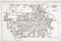
| Description: | A map of the village of Verona, Wisconsin. |

| Date: | 1877 |
|---|---|
| Description: | Map of northern Wisconsin showing the lands owned by Cornell University (shaded portions) in 1877. The map depicts the lakes, river systems, towns, and th... |
| Date: | |
|---|---|
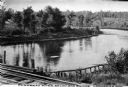
| Description: | View of the Flambeau River from Soo Bridge. The railroad bridges crosses over the river and foliage lines the riverbanks. |

| Date: | 1866 |
|---|---|
| Description: | View along earthworks overlooking the Etawah River and a railroad bridge. A tree stripped of branches and bark is on the left. Plate 23 |

| Date: | 1918 |
|---|---|
| Description: | A map of primarily of Wisconsin, but also includes the areas of northern Illinois, eastern portions of Minnesota and Iowa, and Michigan’s Upper Peninsula, ... |

| Date: | |
|---|---|
| Description: | A railroad bridge crosses over Red Cedar River. |

| Date: | |
|---|---|
| Description: | Map of Baraboo and its surroundings, showing the ancient mound city, the water power, and thoroughfares, drawn by William H. Canfield. Canfield includes sk... |
| Date: | |
|---|---|
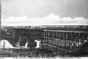
| Description: | Elevated view of the Wisconsin Central Railroad Bridge. Wisconsin Central Railroad Company was incorporated in February 1871. Caption reads: "Wisconsin Cen... |

| Date: | 1902 |
|---|---|
| Description: | Two panoramic bird's-eye views of the Paine Lumber Company, including the general plant, sawmill, and lumber yards. Heading at the top says: Home of Wiscon... |

| Date: | 1847 |
|---|---|
| Description: | A color map of Kentucky with insets showing Lexington, the Falls of Ohio, and the Ohio River. |

| Date: | 1883 |
|---|---|
| Description: | Bird's-eye view of Montello, county seat of Marquette County. The granite quarry, woolen mill, and planing mill are clearly identified. A steamboat on Buf... |

| Date: | |
|---|---|
| Description: | Elevated view of Dawson and Klondike City, looking north. Klondike Brewery is labeled in the foreground at left. Published by Landahl's Emporium. |

| Date: | 1914 |
|---|---|
| Description: | Plat book of Waukesha County. Pages 14 - 15. |

| Date: | 1914 |
|---|---|
| Description: | North part of Waukesha County. From Atlas of Waukesha County. Pages 10 - 11. |

| Date: | 1944 |
|---|---|
| Description: | Aerial view of the U.S. Rubber Company plant and surrounding environment. |

| Date: | 1925 |
|---|---|
| Description: | This map shows state trunk highways, county trunk highways, railroads, canoe trails, lakes, and free public camp sites. The map on the reverse also shows a... |
If you didn't find the material you searched for, our Library Reference Staff can help.
Call our reference desk at 608-264-6535 or email us at: