Filter: Categories of Wisconsin Historical Images
Filter: Subject of Railroads
Filter: Subject of rivers
Filter: Categories of Wisconsin Historical Images
Filter: Subject of Railroads
Filter: Subject of rivers

| Date: | |
|---|---|
| Description: | View from hill towards the elevated Chicago, St. Paul, Minneapolis and Omaha railroad bridge over the Chippewa River at Eau Claire. |

| Date: | 1853 |
|---|---|
| Description: | Shows railroads, planned and in place. |

| Date: | 1887 |
|---|---|
| Description: | Benedict & Co. engineers. As shown by development to March 1st 1887. Inset: Map of northern Wisconsin showing location of range. Lands in red. |

| Date: | 1915 |
|---|---|
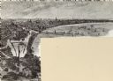
| Description: | Advertisement reads: "Castle-Pierce Printing Company" and "Feb. 1915". Text on right reads: "The Heart of Oshkosh. This birds-eye view represents about one... |

| Date: | 1852 |
|---|---|
| Description: | Map reads: "The State of Wisconsin- compiled from the latest authorities". In addition, there is a scale which is six miles for every inch, and a profile o... |

| Date: | 1919 |
|---|---|
| Description: | This is a collection of three hand-colored plat maps. One map is a plat plan and includes annotations and an index that shows public land, business, indust... |

| Date: | 1861 |
|---|---|
| Description: | A map of Wisconsin showing cities, counties, major roads, railroads, and bodies of water. Includes an inset of the vicinity of Milwaukee. |

| Date: | 1890 |
|---|---|
| Description: | This map shows lakes, railroads, and rivers. An explanation of railroad lines with mileage in Wisconsin and total mileage for 1890 is included. Portions of... |
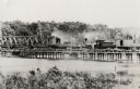
| Date: | 1885 |
|---|---|
| Description: | Partial removal of railroad bridge over Rock River. A train is on a section not being removed in order to transport men and materials. |
| Date: | |
|---|---|
| Description: | A woman sits among a group of logs on the shoreline of a river. In the background, a railroad bridge is visible. |

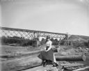
| Date: | |
|---|---|
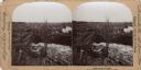
| Description: | Three women playfully pose among logs near a railroad bridge that passes over a dam. On the bridge, a standing man is visible. |

| Date: | 1915 |
|---|---|
| Description: | Plat map of Polk township in Washington County. |
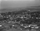
| Date: | 04 21 1949 |
|---|---|
| Description: | Aerial view of Spring Green. Houses and commercial buildings are in the foreground and a rural area is in the background. Hills are in the distance. |

| Date: | 1878 |
|---|---|
| Description: | View from riverbank of the Chicago Milwaukee and St. Paul railroad locomotive no. 142 on the Kilbourn bridge. |
| Date: | 06 12 1899 |
|---|---|
| Description: | Elevated view of a town with a railroad bridge crossing over a river. Several individuals are visible crossing the bridge. Sign near bridge says: "Willow R... |

| Date: | 1873 |
|---|---|
| Description: | Color outline map of Dane County, Wisconsin. |
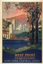
| Date: | 1928 |
|---|---|
| Description: | An original lithograph promoting New York Central Lines railway and the West Point military academy, in a location described as being "In the highlands of ... |

| Date: | 1855 |
|---|---|
| Description: | Map of Milwaukee, Waukesha, Racine, and Kenosha Counties with part of Walworth County showing townships, waterways, railroads, plank roads, prairies, meado... |
If you didn't find the material you searched for, our Library Reference Staff can help.
Call our reference desk at 608-264-6535 or email us at: