 Filter: Categories of Wisconsin Historical Images
Filter: Subject of Railroads
Filter: Subject of maps
Filter: Categories of Wisconsin Historical Images
Filter: Subject of Railroads
Filter: Subject of maps

| Date: | 1871 |
|---|---|
| Description: | This map shows the entire state, county boundaries, railroads, cities and towns, Lake Superior, and the extent of surveyed townships with Public Land Surve... |

| Date: | 1892 |
|---|---|
| Description: | This map shows the entire state with railroad routes shown in red, blue, orange, green, brown, pink, green, and black. Also labeled are counties, cities, t... |

| Date: | 1894 |
|---|---|
| Description: | This map shows the entire state with railroad routes shown in red, blue, orange, green, brown, pink, green, and black. Also labeled are counties, cities, t... |

| Date: | 1920 |
|---|---|
| Description: | This map shows the entire state as well as portions of Iowa, Illinois, Minnesota, and Michigan. Counties outlined in yellow, cities, rivers, lakes, and rai... |

| Date: | 1966 |
|---|---|
| Description: | This blue line print shows existing and proposed streets, docks, company-owned land, railroads and railroad yards, parks, and municipal airport. |
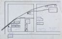
| Date: | |
|---|---|
| Description: | Line drawing on tissue paper showing the layout of the Gisholt plant buildings over two blocks at East Washington and Baldwin Streets. Shows streets and ra... |

| Date: | 1937 |
|---|---|
| Description: | Map showing territory controlled by the Finches, a family of bandits who terrorized south central Wisconsin in the years prior to the Civil War. The map in... |
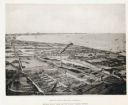
| Date: | 1892 |
|---|---|
| Description: | Bird's-eye view of Cudahy showing stock yards and the Cudahy packing houses. A train runs through the center of the image on the Chicago & Northwestern Rai... |
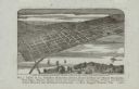
| Date: | 1880 |
|---|---|
| Description: | Bird's-eye map of the city of Madison. Caption reads: "City of Madison — From Park's 'History of Madison, Dane County, and Surrounding Towns.'" The text un... |
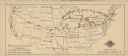
| Date: | 1924 |
|---|---|
| Description: | Map of the United States with tour route taken by the Chicago Civic Opera Company indicated in red. The company traveled on the Baltimore & Ohio Railroad S... |

| Date: | 1867 |
|---|---|
| Description: | A map and profile map of the railroad line from Omaha to San Francisco. |

| Date: | 11 03 1903 |
|---|---|
| Description: | A drawing of a group of burial mounds in Linden Valley. Text on back reads: "These mounds lie at the narrow mouth of Linden Valley on the east side of the ... |
If you didn't find the material you searched for, our Library Reference Staff can help.
Call our reference desk at 608-264-6535 or email us at: