 Filter: Categories of Wisconsin Historical Images
Filter: Subject of Railroads
Filter: Subject of locks (hydraulic engineering)
Filter: Categories of Wisconsin Historical Images
Filter: Subject of Railroads
Filter: Subject of locks (hydraulic engineering)

| Date: | 1892 |
|---|---|
| Description: | This map shows the dams and locks of the Fox River between Neenah, in Winnebago County, Wisconsin, and Kaukauna, in Outagamie County. The cities and villag... |
| Date: | 1927 |
|---|---|
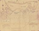
| Description: | Shows landowner's lots, roads, railroads, and Fox River. Also includes certificate of survey text. Includes significant manuscript annotations depicting th... |

| Date: | 1857 |
|---|---|
| Description: | This map shows lot and block numbers, streets, railroad depots, locks, bridges, dams, canals, U.S. light house, college grounds, a steam boat landing, and ... |
| Date: | 1897 |
|---|---|
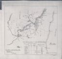
| Description: | This map shows the distances along Fox River, as well as adjacent lakes and railroads, between Green Bay and the Wisconsin River. Lake Michigan is on the f... |
If you didn't find the material you searched for, our Library Reference Staff can help.
Call our reference desk at 608-264-6535 or email us at: