 Filter: Categories of Wisconsin Historical Images
Filter: Subject of Railroads
Filter: Subject of land
Filter: Categories of Wisconsin Historical Images
Filter: Subject of Railroads
Filter: Subject of land

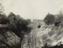
| Date: | 1866 |
|---|---|
| Description: | View along earthworks overlooking the Etawah River and a railroad bridge. A tree stripped of branches and bark is on the left. Plate 23 |

| Date: | 1918 |
|---|---|
| Description: | A map of primarily of Wisconsin, but also includes the areas of northern Illinois, eastern portions of Minnesota and Iowa, and Michigan’s Upper Peninsula, ... |

| Date: | |
|---|---|
| Description: | A railroad bridge crosses over Red Cedar River. |

| Date: | |
|---|---|
| Description: | Map of Baraboo and its surroundings, showing the ancient mound city, the water power, and thoroughfares, drawn by William H. Canfield. Canfield includes sk... |
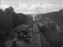
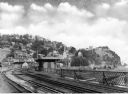
| Date: | 11 30 1915 |
|---|---|
| Description: | Elevated view towards a train depot located in a valley. |
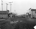
| Date: | 1913 |
|---|---|
| Description: | View down of Main Street, which is a dirt street passing through the central business district of the town, featuring several storefronts with porches and ... |
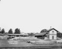
| Date: | |
|---|---|
| Description: | Elevated view across railroad tracks of a lumber yard. A two-story building on the right has a sign that says: "Lovejoy & Ringham". There are fences, a sto... |
| Date: | |
|---|---|
| Description: | Elevated view of a railroad station at Beaver Lake. Men gather in front of the station on the left where horses and carriages are parked. Signs on the stat... |

| Date: | 1847 |
|---|---|
| Description: | A color map of Kentucky with insets showing Lexington, the Falls of Ohio, and the Ohio River. |
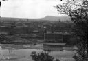
| Date: | |
|---|---|
| Description: | Elevated view of town buildings as seen from Bancroft Tower. A body of water and what appears to be an industrial plant are in the foreground. |

| Date: | 1886 |
|---|---|
| Description: | Wisconsin map showing land offices, railroads completed, railroad land grants and Indian reservations. |

| Date: | 1909 |
|---|---|
| Description: | Map of Sawyer County with an advertisement for land sales through Fuley & Quail of Hayward, Wisconsin. There is a small inset map of railroads accessible i... |
| Date: | 1925 |
|---|---|
| Description: | View from the Baltimore and Ohio Railroad Station, established in 1830. The city's dwellings and establishments can be seen on a hillside from the railroa... |
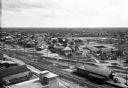
| Date: | |
|---|---|
| Description: | Elevated view of town buildings with railroad tracks running through the town. A railroad depot stands in the foreground. |

| Date: | |
|---|---|
| Description: | Elevated view of Dawson and Klondike City, looking north. Klondike Brewery is labeled in the foreground at left. Published by Landahl's Emporium. |

| Date: | |
|---|---|
| Description: | Elevated view of the city and the surrounding bay and hills. Text reads, "Terminus of Alaska C.R.R." |

| Date: | 1914 |
|---|---|
| Description: | Plat book of Waukesha County. Pages 14 - 15. |

| Date: | 1914 |
|---|---|
| Description: | North part of Waukesha County. From Atlas of Waukesha County. Pages 10 - 11. |
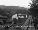
| Date: | 08 29 1930 |
|---|---|
| Description: | View from top of new bridge of construction grounds at the bridge site. There are cars carrying building materials on the railroad tracks by the Bridgeport... |
If you didn't find the material you searched for, our Library Reference Staff can help.
Call our reference desk at 608-264-6535 or email us at:
