Filter: Categories of Wisconsin Historical Images
Filter: Subject of Railroads
Filter: Subject of land
Filter: Categories of Wisconsin Historical Images
Filter: Subject of Railroads
Filter: Subject of land
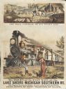
| Date: | 1875 |
|---|---|
| Description: | Colored print containing two images advertising the delivery of mail. The main image is of the large Michigan and Southern train labeled "The Fast Mail" de... |

| Date: | 1882 |
|---|---|
| Description: | The official railroad map of Wisconsin showing railroad lines throughout the state. |

| Date: | 1884 |
|---|---|
| Description: | The official railroad map of Wisconsin showing railroad lines throughout the state. |

| Date: | |
|---|---|
| Description: | A view of a train crossing the Yukon Railway Bridge at White Pass, with pedestrians on one the side of the tracks. Caption reads: "White Pass And Yukon R.Y... |

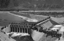
| Date: | |
|---|---|
| Description: | Elevated view of the camp and valley of the site of the Elephant Butte Dam near Truth or Consequences. There are buildings, roads, railroad tracks, and tra... |

| Date: | 1896 |
|---|---|
| Description: | Section 5 of 12, this bicycle road map features Wisconsin bicycle routes in the counties of La Crosse, Monroe, Vernon, Crawford, Richland, Sauk, Juneau, an... |
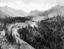
| Date: | 1930 |
|---|---|
| Description: | Elevated view of the Cripple Creek Short Line Railroad and a train winding through the mountains. |
| Date: | 1903 |
|---|---|
| Description: | Elevated view of Derby Diversion Dam with a crowd gathered on the rim of the dam and individuals standing along its top. A train cuts across the horizon in... |
| Date: | 1910 |
|---|---|
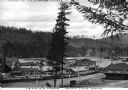
| Description: | Elevated view of the railroad shipping yards of the Idaho and Washington Northern Railway. Included in the image are numerous buildings, workers, trees, an... |

| Date: | |
|---|---|
| Description: | Elevated distant view of the town of Medicine Hat, Alberta and a Canadian Pacific Railway Bridge. Caption reads: "General View of Medicine Hat, Alta. Showi... |
| Date: | |
|---|---|
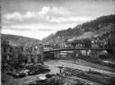
| Description: | Elevated view of the Washington Bridge, crossing over numerous railroad tracks. In the foreground is a train engine, dwellings, and a dilapidated brick str... |

| Date: | |
|---|---|
| Description: | Elevated view of the city, which includes a factory, numerous buildings, railroad tracks, a bridge, Elizabeth river, and hills in the background. |

| Date: | |
|---|---|
| Description: | Elevated view of city, including miners' homes set in the hills, and in the foreground railroad tracks and numerous cars parked along the street in front o... |

| Date: | |
|---|---|
| Description: | Elevated view of an oil field. In the foreground is a railroad train, and numerous shacks. |

| Date: | 1867 |
|---|---|
| Description: | A map showing railroad land in Chippewa Valley. |

| Date: | 1863 |
|---|---|
| Description: | A map of Illinois showing all railroads, stations, and towns. |

| Date: | 1896 |
|---|---|
| Description: | A map of the Chain-O-Lakes in Waupaca, including Indian trails. The path of the Waupaca Electric Railway from the Grand View Hotel to the Wisconsin Central... |

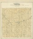
| Date: | 1890 |
|---|---|
| Description: | A plat map of a portion of Verona in Dane County. |
If you didn't find the material you searched for, our Library Reference Staff can help.
Call our reference desk at 608-264-6535 or email us at: