Filter: Categories of Wisconsin Historical Images
Filter: Subject of Railroads
Filter: Subject of land
Filter: Categories of Wisconsin Historical Images
Filter: Subject of Railroads
Filter: Subject of land
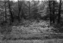
| Date: | 1997 |
|---|---|
| Description: | Black River State Forest, two miles south of US 54 in the Jackson County Forest. The sand track in the foreground is the grade of the old narrow gauge rail... |

| Date: | 1890 |
|---|---|
| Description: | This map shows lakes, railroads, and rivers. An explanation of railroad lines with mileage in Wisconsin and total mileage for 1890 is included. Portions of... |
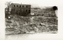
| Date: | |
|---|---|
| Description: | Elevated view across water towards a building at the top of a steep incline, with a small group of people to the left. On top of the hill to the right are ... |

| Date: | 02 09 1949 |
|---|---|
| Description: | Aerial view of Madison, looking east across the Isthmus including the Wisconsin State Capitol, Lake Mendota, and Lake Monona. |

| Date: | 1915 |
|---|---|
| Description: | Plat map of Polk township in Washington County. |
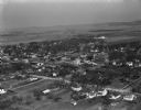
| Date: | 04 21 1949 |
|---|---|
| Description: | Aerial view of Spring Green. Houses and commercial buildings are in the foreground and a rural area is in the background. Hills are in the distance. |
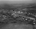
| Date: | 04 30 1949 |
|---|---|
| Description: | Aerial photograph of Barneveld, Wisconsin. |

| Date: | 06 1899 |
|---|---|
| Description: | Elevated view of New Richmond after the tornado hit on June 12, 1899. Many people are gathered around the railroad tracks and a few others are seen among t... |
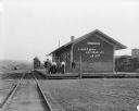
| Date: | 1909 |
|---|---|
| Description: | View from railroad tracks of a group of six people standing on the platform of the Chicago, Milwaukee and St. Paul depot. Beyond the depot is a water tower... |
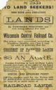
| Date: | |
|---|---|
| Description: | Advertising card for Wisconsin Central Railroad land for sale at $5 an acre. |

| Date: | 1878 |
|---|---|
| Description: | View from riverbank of the Chicago Milwaukee and St. Paul railroad locomotive no. 142 on the Kilbourn bridge. |

| Date: | 1873 |
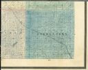
|---|---|
| Description: | Color outline map of Dane County, Wisconsin. |
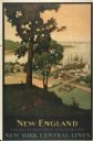
| Date: | 1947 |
|---|---|
| Description: | An original lithograph promoting New York Central Lines railway and the area of New England, deemed "America's Historic Summerland" in the poster. Featurin... |
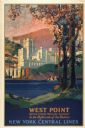
| Date: | 1928 |
|---|---|
| Description: | An original lithograph promoting New York Central Lines railway and the West Point military academy, in a location described as being "In the highlands of ... |
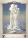
| Date: | 1947 |
|---|---|
| Description: | An original lithograph promoting the Northern Pacific Railway's Yellowstone Park line. Featuring the work of artist Edward Brener, the poster depicts the O... |
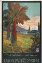
| Date: | 1934 |
|---|---|
| Description: | An original lithograph promoting the South Pacific System railway and southern California. Featuring the artist M. Gundlach, the poster depicts the rolling... |

| Date: | 1855 |
|---|---|
| Description: | Map of Milwaukee, Waukesha, Racine, and Kenosha Counties with part of Walworth County showing townships, waterways, railroads, plank roads, prairies, meado... |

| Date: | 1947 |
|---|---|
| Description: | An original lithograph promoting Mt. St. Helens, and to get there by way of the Northern Pacific Railway. Featuring the artwork of Gustav Krollmann, it dep... |
If you didn't find the material you searched for, our Library Reference Staff can help.
Call our reference desk at 608-264-6535 or email us at: