Filter: Categories of Wisconsin Historical Images
Filter: Subject of Railroads
Filter: Subject of human settlements
Filter: Categories of Wisconsin Historical Images
Filter: Subject of Railroads
Filter: Subject of human settlements

| Date: | 1912 |
|---|---|
| Description: | Exterior view of an International Harvester Transfer Agency building with several men standing on a platform surrounding it. Railroad tracks are located on... |
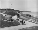
| Date: | 05 30 1914 |
|---|---|
| Description: | Juneau Park looking north from approximately E. Mason Street, with the Chicago and North Western railroad tracks on the right. The Lake Michigan shoreline ... |

| Date: | 09 1918 |
|---|---|
| Description: | Elevated view of the U.S. Government War Exposition grounds at Grant Park. |

| Date: | 1852 |
|---|---|
| Description: | Map reads: "The State of Wisconsin- compiled from the latest authorities". In addition, there is a scale which is six miles for every inch, and a profile o... |
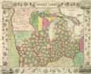
| Date: | 1849 |
|---|---|
| Description: | Map reads, "Map of the Western States". Published by Ensign & Thayer. There is a decorative vine border, and in each corner there is an engraving of four c... |
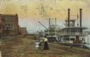
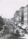
| Date: | 1910 |
|---|---|
| Description: | Caption reads: "Riverfront from Pettibone Park, La Crosse, Wis." There are three steamboats docked on the right in the harbor. A mother and her children ar... |
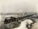
| Date: | 03 09 1927 |
|---|---|
| Description: | A train carrying tractors stopped on its way from Milwaukee Works (factory). |

| Date: | 1919 |
|---|---|
| Description: | This is a collection of three hand-colored plat maps. One map is a plat plan and includes annotations and an index that shows public land, business, indust... |

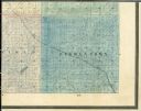
| Date: | 1861 |
|---|---|
| Description: | A map of Wisconsin showing cities, counties, major roads, railroads, and bodies of water. Includes an inset of the vicinity of Milwaukee. |

| Date: | 1872 |
|---|---|
| Description: | Map entitled Office Wallbridge Bro. U. Sargent showing upper Minnesota and Wisconsin, as well as Lake Superior. |

| Date: | 1851 |
|---|---|
| Description: | Map of the Lake Superior region showing the railroad and steamboat connection. |

| Date: | 1858 |
|---|---|
| Description: | Map of the Lake Superior region showing the railroad and steamboat connections. |
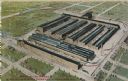
| Date: | 1910 |
|---|---|
| Description: | Aerial view of the factory surrounded by fields, roads, and several houses, as well as the railroad tracks that go around the building. Caption reads: "Wes... |
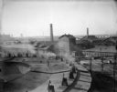
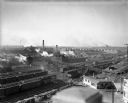
| Date: | 1940 |
|---|---|
| Description: | Located in West Milwaukee. View from atop a building of a large building located in the center, next to a smokestack. In the foreground is part of a round... |
| Date: | 1940 |
|---|---|
| Description: | Located in West Milwaukee. Trains, cars, tracks, and railroad buildings. The view is taken from the top of a building. |
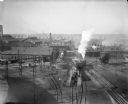
| Date: | 1940 |
|---|---|
| Description: | West Milwaukee. Elevated view of tracks, trains, and buildings. A train roundhouse is located in the background. |

| Date: | 1943 |
|---|---|
| Description: | Elevated view of Wisconsin Avenue, looking east from Court of Honor. Caption reads: "Court of Honor, Looking East, Milwaukee, Wisconsin." |

| Date: | 1915 |
|---|---|
| Description: | Elevated view of the Wells Street Viaduct. Caption reads: "Wells Street Viaduct, Milwaukee." |
If you didn't find the material you searched for, our Library Reference Staff can help.
Call our reference desk at 608-264-6535 or email us at: